 ">
">
The First 100 Miles on the PCT
The first 100 miles on the PCT are done. Seven days full of adventure, learnings, and meeting new people. I’m very happy so far with how it went and how it goes.
There are two things I didn’t expect on the trail:
1. The extreme weather: From day 1 where it was scorching hot to temperatures below freezing just two days later. It changes so quickly and I wasn’t really prepared for the cold nights outside.
2. How beautiful the trail is, already at the beginning of it. I thought the desert section wouldn’t be as diverse as it actually is. The landscape just keeps getting more and more beautiful around every corner.
But one after another. After one full day of recovering from my food poisoning, I took the bus to Campo where I rested for another afternoon at the CLEEF campground to finally hit the trail on the 9th of April, two days later than planned. For three days I could barely eat and felt very tired. I also discovered that it’s not possible to make the hip belt of my backpack any tighter. So hopefully hiker hunger kicks in soon.
I highly recommend CLEEF to stay for the night, meet new people and have a fresh start in the morning at the Southern Terminus, which is just a 10-minute walk away. People there are amazing, full of advice, stories, and dinner and pancake breakfast are great. We had a nice campfire in the evening and the sky was full of stars. The fresh air helped me a lot to get better and in the evening I was even able to get down an entire burger. I was ready to do this!
Finally Day 1: The Start
Southern Terminus to Hauser Creek
25km (15.5 mi) / 6.5h / elevation gain of 529m (1,735ft)
The next morning we went to the border, signed in the trail register, and had a chat with the friendly people from the PCTA. A couple of photos later we were on our way to Canada. It was already hot in the morning and there is not much shadow at the beginning of the trail. We walked back to the campground and on to the last water source for today at mile 4.4. I took 6L as I didn’t know how much I would need for 1.5 days. You always pack your fears, as they say, and I heard stories of people who ran out of water. So I wanted to make sure. In the end, I just used like 2.5L of water.
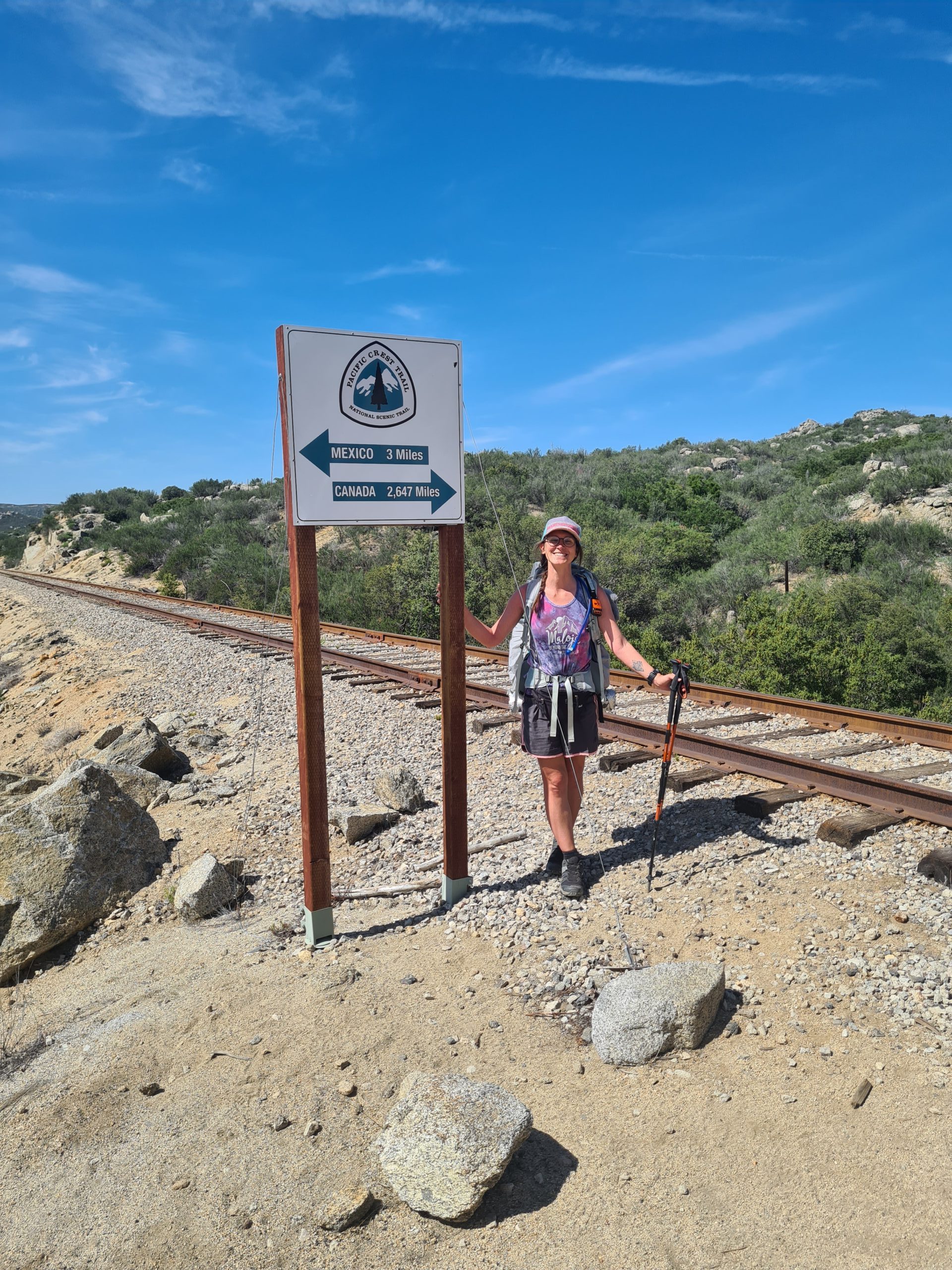
Just 2,647 miles to go to Canada.
So I carried on with a backpack way too heavy with all that water. We saw our first rattlesnake who complained loudly about our disturbance and vanished into the bushes. The trails went uphill, but it’s never steep and there are some shady spots along the way where we took small breaks. We reached the highest point for today at 1,042m (3,400ft) and from there on it’s just downhill to Hauser Creek, where there is no creek at the moment. We could already see the intimidating ascent for tomorrow on the other side. But for now, we were happy to reach the campsite for tonight. We did cowboy camping on our first night but I was too tired to appreciate the starry night sky for long.

We can already see the ascent of the next morning out of Hauser Creek.
Day 2: First Burger on the Trail
Hauser Creek to Kitchen Creek
24km (15mi) / 6h / elevation gain of 894m (2,933ft)
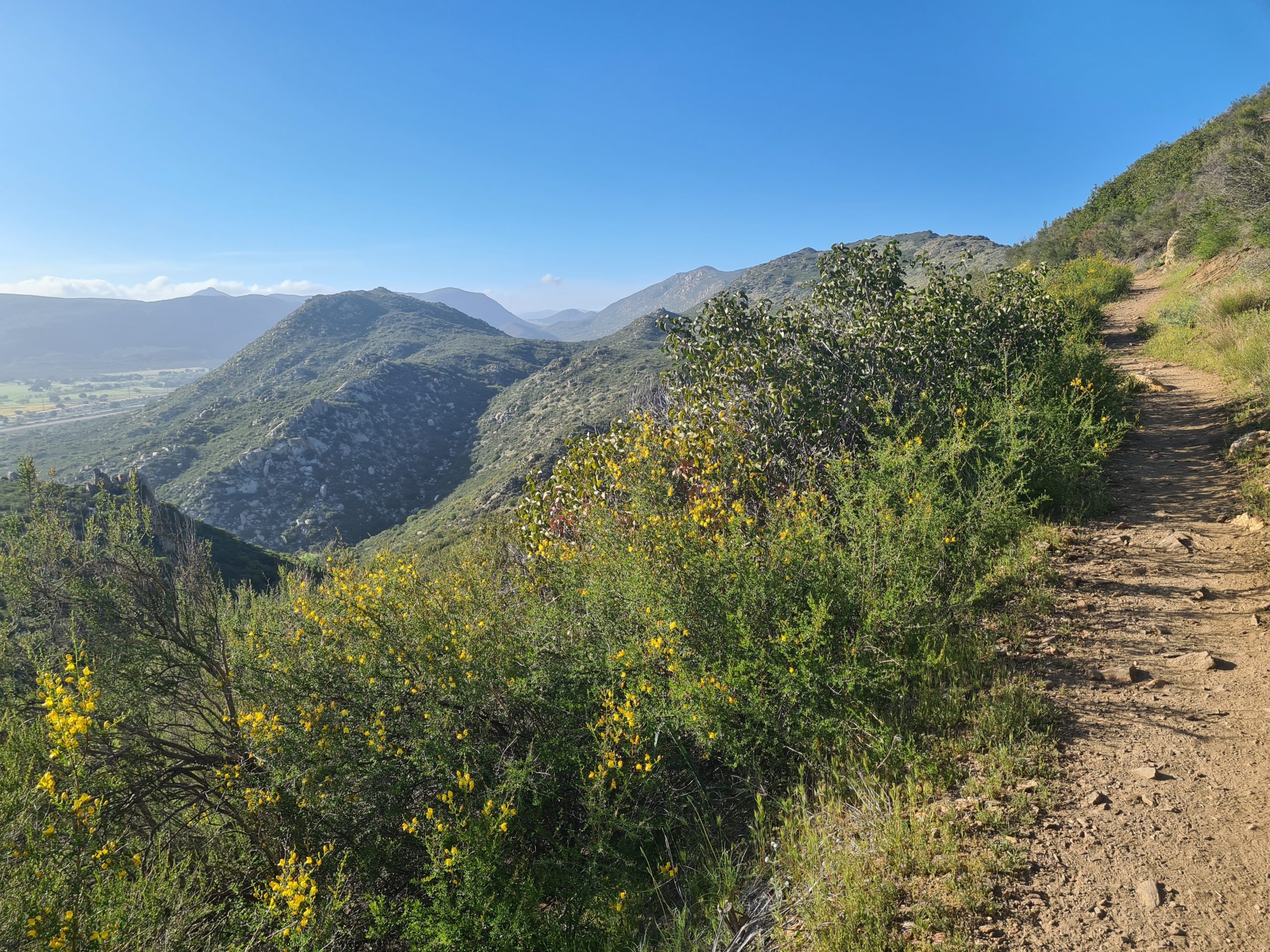
The night was quite cold at around 5°C (41°F) – what a huge difference from the 30°C (86°F) the day before. We tackled the ascent we already saw yesterday in the nice cool morning. It is an easy climb as it’s never too steep. Then the trail continued relatively flat until we had our first view of Lake Morena. We were rushing downhill to reach the lake and went a bit off-trail to go to the Oak Shores Malt Shop to have Soda and Burger. There is more than enough to resupply here, so you wouldn’t need much food on the first day.

Way to Mount Laguna.
On the way ahead we encountered another snake, this time a small one. God knows what kind of snake it was, but we gave it the space to move from the trail. The trail went slightly uphill and soon we were having a nice view back to Lake Morena. We reached the campground at Boulder Oaks where there was some trail magic as two former thru-hikers handed out some soda and beer. Refreshed we went on uphill on a beautiful way through the mountains. It got more and more beautiful around every corner and I was amazed by that. We cowboy camped again at a little creek full of frogs who gave a nice concert in the evening.

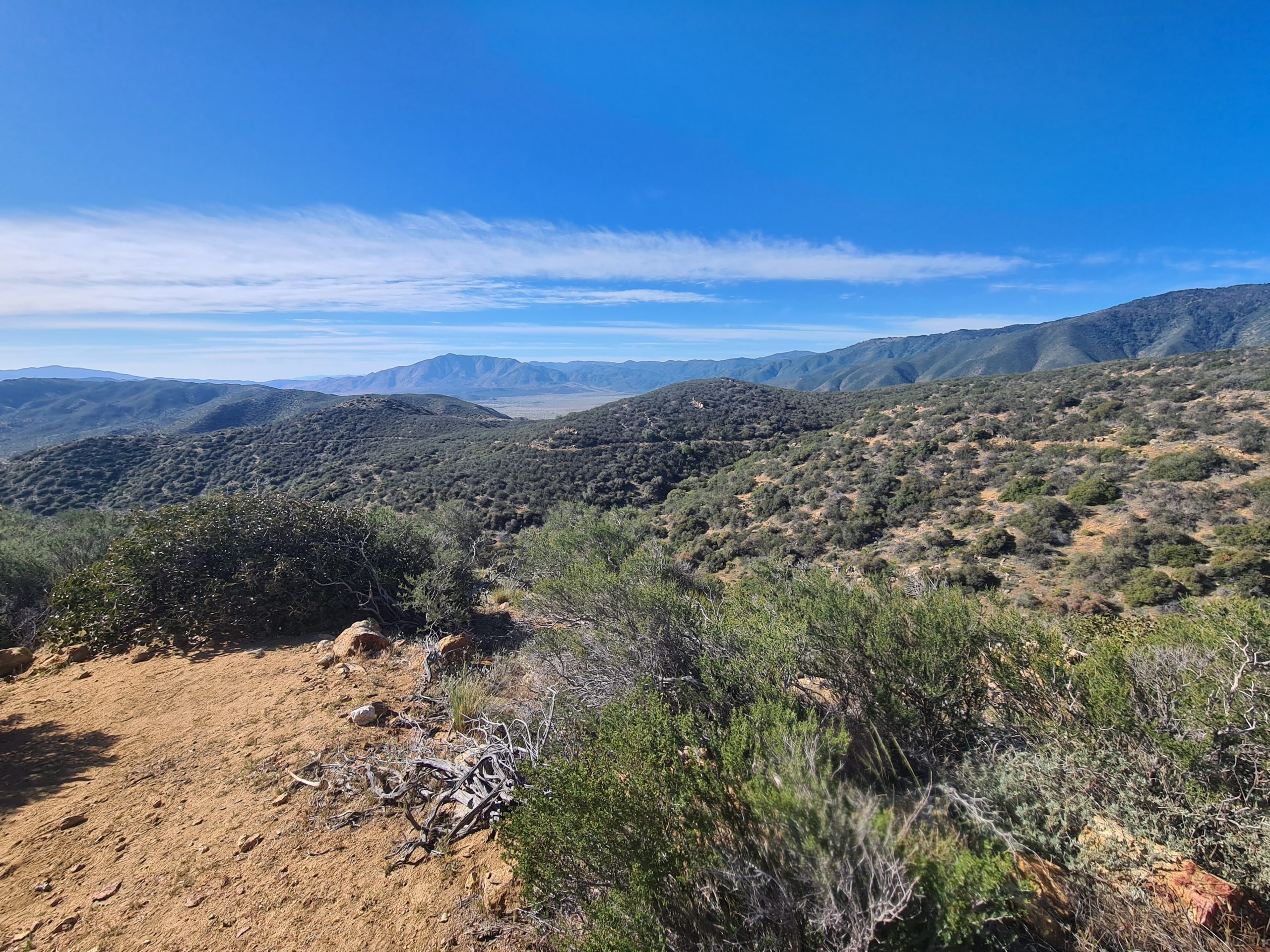
The trail gets more and more beautiful around every corner.
Day 3: Ready to Go Inside
Kitchen Creek to Mount Laguna
19km (12mi) / 4.5h / elevation gain of 820m (2,690ft)
The night was cold again, but I was fine with wearing two pairs of pants. The creek was so nice and peaceful in the morning and we hung around a little longer to soak up some sunshine and enjoy our time. Then we went on our way to Mount Laguna and were already looking forward to some town food in the pub, but unfortunately, this would be disappointed soon. It was way colder today and the wind was quite chilly.

Kitchen Creek in the morning
The trail was leading us through a beautiful hilly landscape with some shrubs and rocks until we went downhill through a little forest. We reached the road to Mount Laguna and left the trail to go into town. Unfortunately, the pub there is closed on Mondays and Tuesdays, so no food for us. What a bummer! We moved into our tiny house that we booked ahead as we saw in the forecast that it would be a very windy, wet, and cold night.

Landscape on the way to Mount Laguna
Luckily the store is open to five p.m. and has quite a good selection, though somewhat expensive. We purchased some spaghetti and sauce and made a big pot for all of us in the hostel kitchen.
We were very happy to stay the night inside because it really got windy and cold. The next morning we heard some horror stories about ripped tents in the middle of the night and it must have been freezing as even the water spigots were frozen.
Day 4: A Cold but Educational Night
Mount Laguna to Oriflamme Canyon
22.7km (14mi) / 5h / elevation gain of 460m (1,509ft)
In the morning it looked so uninviting outside that we stayed in our warm little hut as long as possible. When we started there was sunshine again but it still was cold. We met a lot of hikers at the store in Mount Laguna who spent a miserable and cold night outside and were trying to warm up with hot chocolate. The first miles were cold and the wind was even colder so I had to wear my down jacket. I actually wanted to send my cold-weather gear ahead to Paradise Valley Café at mile 150, and I was so happy now that I didn’t. I really needed everything I had.

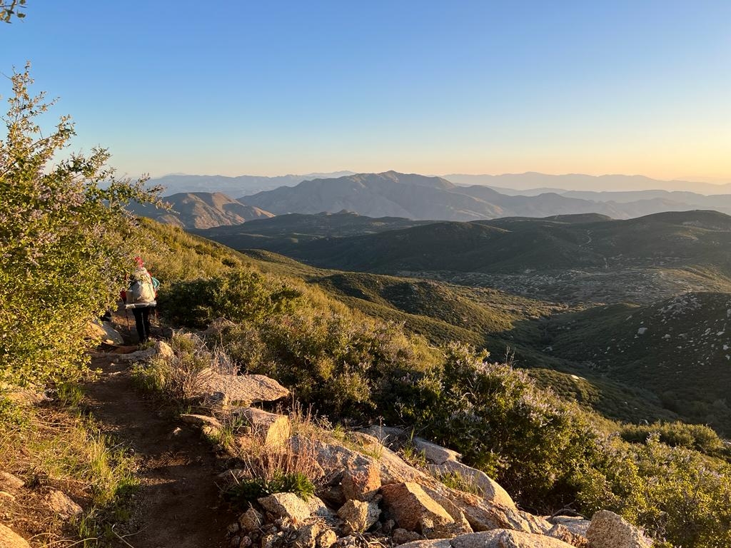
Amazing views on the way out of Mount Laguna.
The trail climbed up and we soon had an amazing view into the valley below us. We took a long curve through the mountains and finally descended to the Pioneer Mail Picnic Area, where there was Trail Magic again! We were lucky to get the last three hot dogs. I am amazed by all the friendly people doing trail magic on the PCT. On the Te Araroa in New Zealand, I had trail magic just like two times on the entire 3,000km (1,860mi).

Ridge walk to Oriflamme Canyon.
On the last miles, there was a stunning ridge walk with great views of the Oriflamme Canyon. Soon we decided to camp between the rocks to get some protection from the wind. We did cowboy camping again and that was a really bad decision. We had a nice sunset though. The night was so cold because of the wind and even after I put on every piece of clothes I had with me, even the gloves, I still was cold. Finally, I decided to take my emergency blanket and wrapped myself in it in my sleeping bag. It still wasn’t warm, but I managed to get a little bit of sleep. At like two a.m., the wind died out quite a bit and I was finally able to sleep.

Sunset before we spent a miserable night
It was a tough night, but I learned three things from it when you expect a cold and windy night:
1. Don’t be lazy. Put up your tent to get some protection.
2. Walk as long as you can as the night will be shorter.
3. Don’t let others talk you out of gear you are convinced of. Somebody tried to talk me out of my emergency blanket at a shakedown but I still took it. It saved my ass that night.
Day 5: A Hard Push into Julian
Oriflamme Canyon to Scissors Crossing (Julian)
35km (21mi) / 7.5h / elevation gain of 524m (1,719ft)
After that horrible night, we decided to make a push all the way to Julian, which would be 35km including a detour to a water source. The good thing about the night was that we woke up early and started hiking at six a.m. So we could make the first 20km (12.5mi) by noon. We hiked six km (3.7mi) to Sunrise Trailhead where we got some water. There was a nice sunrise and it got warmer very quick so I could soon hike in shorts and a shirt again. I would have never thought of that a few hours ago.

Sunrise after a cold night.
Mountain landscape on the way to Scissors Crossing.
We continued our way through the mountains with a lot of up and down. We had some great views of the desert floor below us until we descended there. Suddenly the landscape changed to a desert with a lot of cacti and sand. We walked right next to the road to the junction to Julian where we tried to hitch to town. We really wanted to spend the night inside and rest well after the last night. And I heard the free pie you get in Julian is totally worth the detour. After like 10 minutes we managed to get a ride to town and spent a nice evening with a lot of food at the Italian restaurant. the outfitter and pie shop close at five p.m., so we decided to do that tomorrow. Book ahead if you want to stay in Julian a there are not that many availabilities.

On the desert floor.
Day 6: Through the Desert Mountains
Scissors Crossing to Water Cache at mile 91.2
22km (13.6mi) / 4.5h / elevation gain of 730 m (2,395ft)
We spent the entire morning in Julian, having some great apple pie for free (!) at Mom’s Pie, which is absolutely worth the hype it gets. Then I purchased some stuff from the Outfitter, which is quite small but has everything you would need. I got a pillow, another sleeping pad, and a sleeping bag liner to stay warm at night. Yes, I might have overdone it a little but after the last night I just was too scared to be cold again and there will be colder nights ahead for sure when we would get higher into the mountains.
I took the shuttle that is organized with the guys at the Outfitter and started the trail at 1 pm. I planned to do 22km (8.6mi) to the Water Cache, the only water source between here and Barrel Springs. My friend stayed behind in Julian as she needed some more time to recover from the last days. Julian was way too expensive for me to stay with her, so I continued and we will meet up later.

Up into the mountains behind Scissors Crossing.
It’s quite a climb uphill from Scissors Crossing and I came across a lot of lovely cacti and flowers. Once I was up there the trail continues easily with just a bit of up and down. It made a lot of loops along the side of the mountain. You could see the trail on the other side which looks so close but took a while to get there. For comparison: The road to Warner Springs is 32km (20mi) long, and the PCT takes 51.5km (32mi).

Amazing landscape.
After 14km (8.6mi) there was a nice protected campsite but I wanted to carry on to the water cache at mile 91.2. The trail went up again but in nice graded switchbacks. I always had amazing views down to the desert floor and the mountains on the other side. I arrived at the water cache and found a nice spot for my tent as there is a lot of room. This time I pitched my tent and had a warm and cozy night as the temperature didn’t drop below 10°C. Actually the best night I had on the PCT so far.
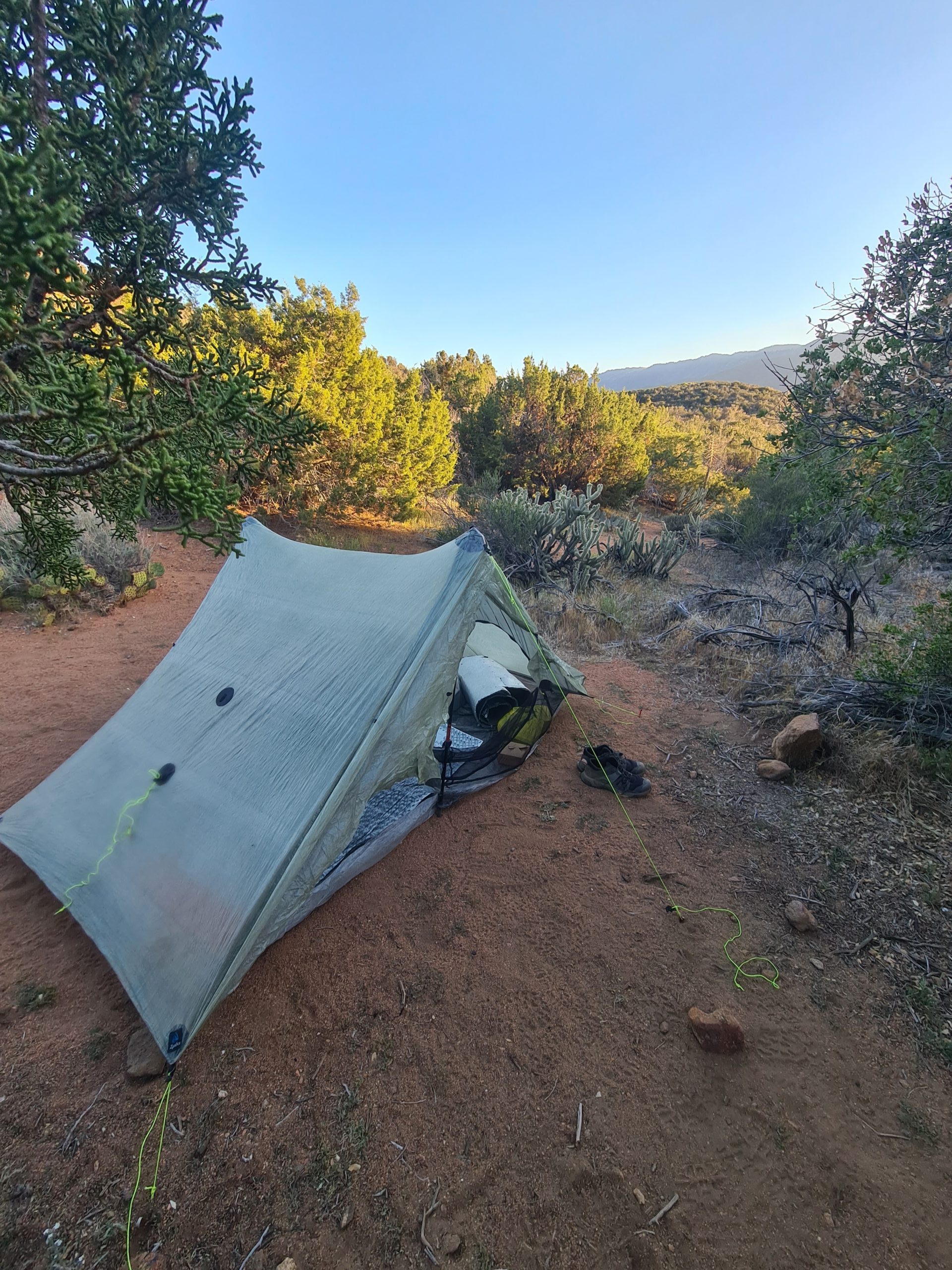
Spot for the night
Day 7: 100 miles done!
Water Cache at mile 91.2 to Barrel Springs (Mountain Valley Resort)
16km (10mi) / 3.5h / elevation gain of 440m (1,443ft)
I just had a short day ahead of me as I wanted to celebrate the first 100 miles done on the trail in the Mountain Valley Retreat which sounded lovely to me. I didn’t even need water from the cache as I still had enough with me. Yep, still carrying too much. I could save quite some weight when I wouldn’t overrate my water consumption. But you never know how hot it’s gonna be and how much you would need. I took my time in the morning and started after eight a.m. as I didn’t have many miles to do today. The trail continued along the mountainside and it was sunny but not too warm – perfect hiking weather. I met quite a lot of Germans today. I was wondering where they all are as I didn’t meet many at the beginning of the trail but here they are.
Views, views, views
Then I passed the 100-mile marker. Yes, I did it! I was skeptical after being so weak after my food poisoning but I’m going strong. I’m more than happy with the progress I made so far. I arrived at Barrel Springs at 1 pm and took the shuttle to the Mountain Valley Retreat. So I had a lot of time for chores, relaxing, and writing in the afternoon. They even have a small resupply where I gonna buy some stuff for the next five days to Idyllwild. I also took care of three blisters I got in the last two days. It’s strange as I didn’t have anything for the first days and then suddenly they popped up one after another. I don’t know what I did differently but I learned to take care of a weird spot immediately instead of waiting it out until it gets too late.

First 100 miles on the PCT done.
To the next 100 miles, I’m looking forward to it! So excited to see what they have in store for me.

This website contains affiliate links, which means The Trek may receive a percentage of any product or service you purchase using the links in the articles or advertisements. The buyer pays the same price as they would otherwise, and your purchase helps to support The Trek's ongoing goal to serve you quality backpacking advice and information. Thanks for your support!
To learn more, please visit the About This Site page.

Comments 3
I enjoyed reading this update. I’m also so glad you give us Americans distance in miles! It’s truly very helpful. And I love your flower/cacti photos and was wondering what you are using to take the photos.
Hi Jim, glad you’re enjoying my update. I’m trying my best to adapt the American language and imperial system. I just have to count in kilometers for myself as miles are too depressing for me as they are just to long 😀 For my photos I just use my smartphone, a Samsung Galaxy S20+ which makes quite nice pictures. I would have loved to bring a real camera, but trying to go as light as possible.