 ">
">
Day 132: Mount Moosilauke
Walking in the Whites
I never envisioned reaching the White Mountains.
Northstar never doubted I’d complete the entire AT, but I knew the facts. Three out of four hikers who start the AT don’t finish. Don’t get me wrong, I thought I had the legs, stamina, desire, and commitment to reach Katahdin, but most people don’t get this far.
Once I stood on the ledge at Virginia’s McAfee Knob, I knew in my heart I could do it all. But for some reason, even at my most confident moments, I never could picture myself hiking the Whites. So, for the last month, hiking these mountains has been one of my main motivational goals. The hope of someday walking above the tree line has helped kept me from quitting.
And now I’m here, standing at a trailhead in Glencliff, New Hampshire, looking up at Mount Moosilauke, the first real climb in the White Mountains.
The Moosilauke Mystique
“Wait, which one was Moosilauke?” is a question no former thru hiker will ever ask. Everyone remembers Mount Moosilauke. It’s the beginning of the White Mountains. It’s the first significant ascent in months. It’s where thru hikers, confident in their hiking legs after four to five months of climbing, stop and wonder what happened to their stamina.
The climb is “only” 3,857 feet over 5.7 miles from valley to summit, a mere 700 feet per mile (13% grade). But a one-mile segment just below the south summit exceeds 1,000 feet per mile (20% grade). For those readers who don’t hike mountains or do math, that’s notching steep.
But the ascent doesn’t earn most of the hiker chatter. It’s the descent that really gets hikers’ attention. The steepest part of the descent drops more than 1,800 feet per mile (34%). I read one hiker’s comment bragging that she’d finished the 3.5-mile descent in under four hours. For many hikers, their time is irrelevant, they just want to finish the descent uninjured.
The Ascent
Northstar dropped Gus and I at the Glencliff Trailhead around 7:00 a.m. under a blue sky, with only a few debris clouds left over from yesterday’s rain. The trail followed a paved country road for a half mile before turning into the still, dripping woods. It was another chilly, salamander morning.

Then we passed through several flowery, dewy meadows, where we scared up a pair of grouse, Gus’ first encounter with their explosion of wings and sound. He looked back to see if I was okay, but I’d seen them moving before they took off and had braced myself. Then we walked back into the trees and started to climb in earnest.
The steep trail was tough, though the wet, slippery rocks and roots we had to climb over and around were tougher. The mud and large puddles of standing water were the biggest challenge. As I struggled to keep my feet dry, the Civil Engineer in me puzzled over how the trail builders managed to pond up so much water and mud on a 13% grade. It seems like gravity should take care of that without much effort.

But other than another migraine, the ascent was fine. It was not easy, but as we climbed into the clouds now covering the summit, Gus shrugged and asked, “What’s all the fuss about that?” We’d managed an acceptable two miles per hour and hadn’t even had to break out the audiobook.
The Summit
The wind howled and wisps of mist whipped across the bare rocks as we reached the summit. We’d been buried in fog for the last 30 minutes of the climb, so we expected nothing less. I recorded a “You probably can’t hear me…” video at the rock cairn marking the peak as an homage to all the too-windy AT vlogs I’ve watched.
Even though we had no view through the clouds, it somehow felt different than getting skunked on views in Vermont. Today, at least we’d gotten above the tree line and had a chance at a view. And from the look of the sky, if we sat around for a few hours, we might see a spectacular 360-degree panorama.
But I’d heard that someone had set up trail magic at Kinsman Notch, so Gus and I decided to bet on a sure-thing hot dog rather than on anyone’s guess at a possible break in the clouds.
The Descent
The climb back down the mountain started off pleasantly enough. The trail passed through a dense stand of fragrant spruce trees that gently brushed at my elbows, happily reminding me of picking out Christmas trees as a child. I love walking through spruce forests. Maybe the climb down Moosilauke wouldn’t be so bad after all.

And then the bottom dropped out.
What part of steep descents do I like least? Miles of huge, knee-busting rock steps? Steep, rain-slick, bedrock faces? Ankle-breaking, slippery-as-whale-snot roots? Toe-width foot and hand holds? Sock soaking mud puddles? Hanging on to trees as I descend? Trusting who-knows-how-old wood block steps attached to bare rock faces? Sliding down slick rock faces on my butt? Jumping off cartilage-shattering ledges?
It didn’t matter. Moosilauke’s descent had all of that and more.

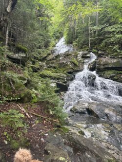
A long chunk of the trail followed a steep, cascading stream. I’m pretty sure the trail builders put the descent by the stream just to remind their victims that at least they weren’t climbing down an actual waterfall. Though, now that I think of it, much of the trail was still flowing with yesterday’s rain. The Civil Engineer in me wondered … no, my engineer packed up and went home muttering something about switchbacks, alternate alignments, and grade, leaving Gus and I to scramble down as best we could.
Spoiler alert: We survived, arriving with sore feet, aching knees, and aan thru-hiker’s appetite at the trail magic at Kinsman Notch just as the sun came out.
Reflections
I’m so glad I didn’t attempt to combine yesterday’s and today’s hikes into a single 19-mile day. Tackling the Moosilauke descent while tired and during yesterday’s drizzle could have easily led to a fall that ended my hike.
I think the trail up and over Moosilauke would be a fun day hike, but I look at the trail differently as a thru hiker. The risk of an injury was too high on the descent, making it too hard to enjoy the challenging terrain.
If today’s trail is any indication, hiking the Whites will be an adventure unlike anything I’ve done so far.
Daily Stats:
- Start: Glencliff Trailhead (Mile 1800.6)
- End: Kinsman Notch (Mile 1808.8)
- Weather: Chilly, sunny early
- Earworm: Those Caissons just keep rolling
- Meditation: Jn 6:27
- Plant of the Day: Canadian bunchberry
- Best Thing: The climb
- Worst Thing: The descent

This website contains affiliate links, which means The Trek may receive a percentage of any product or service you purchase using the links in the articles or advertisements. The buyer pays the same price as they would otherwise, and your purchase helps to support The Trek's ongoing goal to serve you quality backpacking advice and information. Thanks for your support!
To learn more, please visit the About This Site page.

Comments 10
Love the post. Thx.
Thx, T!
Mt. Moosilauke was one of my toughest days, but all the days in the Whites were hard but inspiring. May your efforts be rewarded with awesome views. Stay safe, my brother!
They kicked my butt every day. Type 2 fun.
Good to hear from you!
Glad you’re down safely.
Glad the weather is better!
Thanks, Alison.
“Ankle-breaking, slippery-as-whale-snot roots?”
I do believe you notching cleaned that up a bit!
Stay safe and strong…glad your descent was safe.
Always.
I cried with relief upon reaching the foot of Moosilauke. And I don’t cry! Congratulations on making it down that notching mtn! And living to write about it. Lol
I believe it. Thx!