 ">
">
Katahdin
Going up Katahdin
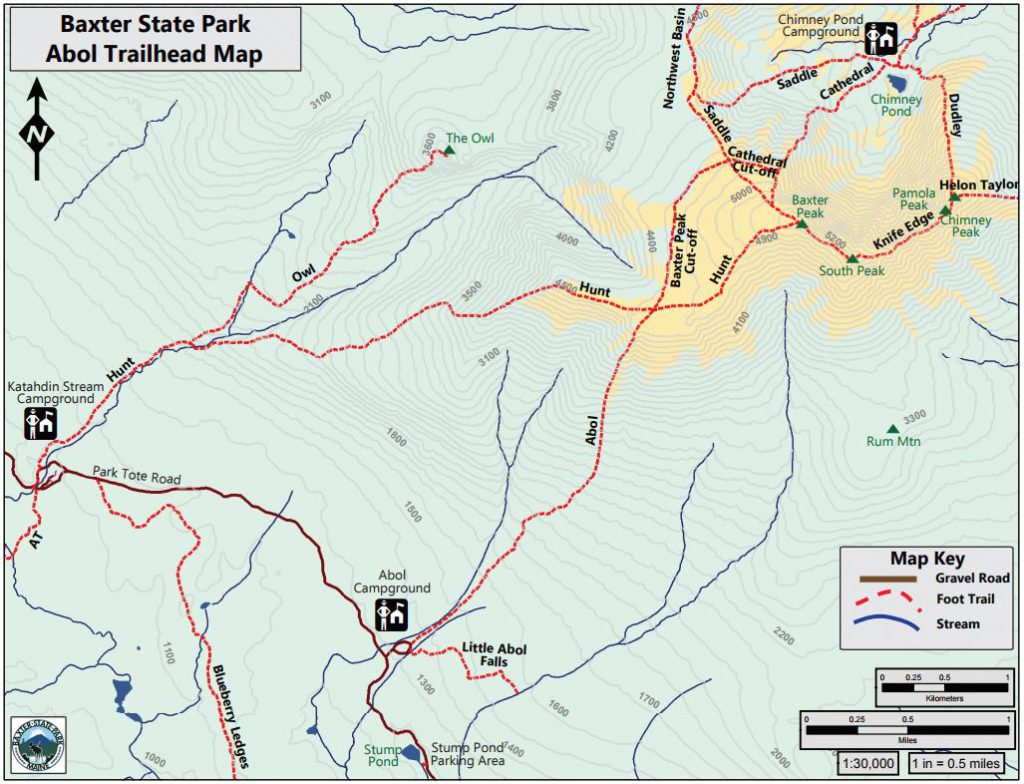
As I wrote in my previous post, my tramily was placed in the Abol campground in Baxter State Park. This campground is ~2 miles from the Hunt trailhead (the official AT trail up Katahdin to Baxter Peak). Most thru-hikers will opt to slackpack Katahdin, leaving the majority of their things at a ranger station, and climbing Katahdin with a daypack, typically taking the Hunt trail up, and the Abol trail is trail known for basically being a giant boulder field) down the mountain.
I, however, had a different plan. I had heard of the Knife’s edge trail, which is a amazingly sketchy trail which one can take down from Katahdin (right up my alley), however, it brings hikers to a totally different section of the park, a parking lot that’s almost a 2-hour drive away from the parking lot for the Hunt trail. Thus, for me, slackpacking was not an option. Additionally, I had scheduled a time to be picked up in this other campground. So, since I love to boulder, was on a time crunch, and the Abol trail was 10 feet away from where I camped, I opted to take the Abol trail up Katahdin, then Knife’s Edge to Helon Taylor to get down. This officially means I am not a purist. But to me, despite what opinions other may have, I still climbed Katahdin (and I had fun doing so).
Trail descriptions according to BSP Website:
The Abol Trail:
“This trail is the shortest route to Baxter Peak from a roadside trailhead. The trail uses the ridge to the west of a rock slide and provides a steady, but steep ascent with excellent views. Water is limited after the first mile and the trail is fully exposed after 2.5 miles. Once on the Tableland you will connect with the Hunt trail (AT) for the last mile.”
Knife’s Edge:
“This route is completely exposed and several people have died or have been seriously injured while attempting a traverse in inclement weather and/or high winds. Do not attempt to leave the ridge once you have started. Hiking Knife Edge across and back is not recommended due to its difficulty and the amount of time it adds to the hike – it takes approximately 1 to 1½ hrs. one way. Access to Knife Edge is from the Roaring Brook Campground. There is no water on this trail.”
Helon Taylor
“This trail allows hikers to have a direct route from Roaring Brook trailhead to connect with the Knife Edge trail at Pamola Peak. It is an extremely exposed trail and because of this, hikes should not be attempted in bad weather.”
My Experience
The day we set to summit turned out to, according to a park ranger I ran into, have the best weather of the season as of yet. My tramily wanted to take the Hunt trail, so they headed off to walk the 2 miles to the trailhead, and I started up Abol. It was sunny and gorgeous, with breathtaking views of Maine as I climbed up.


But then I started to climb into a cloud…

My view once I hit the tablelands
The Summit
As with all great peaks on the AT, despite having great weather in lower elevations, I was socked in when it came to reaching the summit. If I had not told you, from these photos you would never know it was s sunny day.


Coming Down Katahdin – Knife’s Edge & Helon Taylor
There is no denying that I am an adrenaline junkie. So I could not wait for Knife’s Edge. And it did not disappoint.


This may be my favorite picture from Knife’s Edge
As I climbed down of the peak of Katahdin, I lowered down below the cloud, and the views once again became spectacular. As I hiked, I ran into two past thru hikers (Flash Gordon and Miles To Go) who had summited in 2013 and were there for a 10-year anniversary hike. We hiked together across Knife’s Edge.

 Personally, I did not find Knife’s edge to be too scary. But I also know that my tolerance for fear is quite differant than many others. That being said, if you are not afraid of heights, I recommend Knife’s Edge.


 I left Flash Gordon and Miles to Go at the intersection of Knife’s Edge and Helon Taylor. As I climbed down Helon Taylor, the views continued to improve.

And finally I made it down to Roaring Brook Parking lot. It was about 1 o’clock, I had started at 7, so the whole endeavor had only takin me around 4 hours… and I had this huge feeling of “I’ve done it. I’ve summited Katahdin.” I was exhilarated, and exhausted, and needed to go to the ER…. which is the topic of my next post!

This website contains affiliate links, which means The Trek may receive a percentage of any product or service you purchase using the links in the articles or advertisements. The buyer pays the same price as they would otherwise, and your purchase helps to support The Trek's ongoing goal to serve you quality backpacking advice and information. Thanks for your support!
To learn more, please visit the About This Site page.

Comments 3
Congrats and cheers!
Congratulations on conquering the Northern half of the trail and for taking on Katahdin! Thanks for sharing the incredible trek with us. You left us dangling with the ER reference. I hope that turned out OK.