 ">
">
Weekly Trail Update Nine: Days 57 – 62
Welcome back for another trail update!
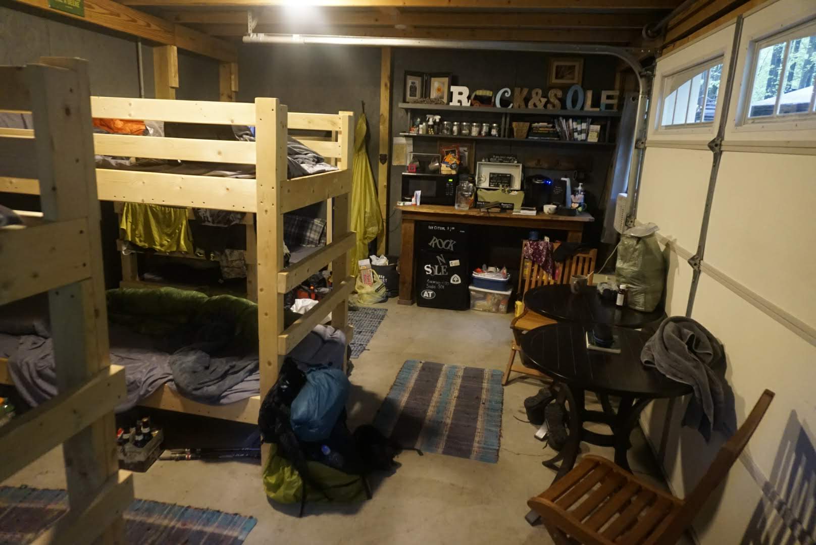
Day 57: Zero Day at Rock N Sole Hostel
As mentioned before, I decided to take a zero day here to let the rain pass and my feet rest. We’re in the eye of a huge storm (and have been for a week) but supposedly it’s moving north so I’m hoping it will clear up so I don’t have to hike the upcoming rocky sections in a complete downpour.
We had breakfast at 7am which I used an egg casserole, French toast, and muffins. It was delicious and I could have easily eaten three more servings! After that, it was back to the bunkhouse to lay down and enjoy the rest. Since there’s no computer, TV, or stores nearby there isn’t much else to do, which is perfectly fine.
As expected, the rain has been nonstop since about midnight. Every couple of hours it dies down a little, but then picks right back up, seemingly worse than before, and so I feel justified in my decision to take the day off.
I didn’t do much throughout the day, which was great. I watched some videos on my phone, chatted with the other guys here, took a nap, and walked maybe a total of a quarter mile all day. It was damn nice. I put my laundry away, refilled my food bag, and resprayed my hiking clothes and gear with pemetherin to dissuade ticks and other bugs.
The Facebook page for the AT posted some disconcerting news on their feed today, saying that due to the recent storm some parks and areas in New York and New Jersey are either closed or nearly impassable. Although I won’t be crossing into New Jersey for another few days and the storm should have passed by then, I suspect the trail will be in pretty poor condition. From various YouTube videos I’ve seen, the upcomi section of the trail is already a bit overgrown in addition to being rocky, so the addition of the storm means that it will probably be flooded and have even more downed trees. Ugh.
Tomorrow I’ll head back to the trail after breakfast and will try to go 30mi. There are a couple of big descents and climbs but otherwise the terrain is pretty flat – it’s the rocks that will be a problem. I’d really like to make it to Delaware Water Gap in 3 days (90mi), which would put me one day closer to being back on schedule. That requires three 30-mile days, which is normally doable but will be tough with the upcoming terrain. I’ll see how it goes.
Day 58: Rock N Sole Hostel to Campsite at mm1234.2 – 30.1mi
I woke up in the hostel this morning feeling quite refreshed, despite having trouble falling asleep last night. There was a guy in the bunkhouse with serious sleep apnea which resulted in loud snoring, choking, and gagging sounds throughout the night. I had earplugs in, but they did little to muffle the noise.
I was up at 6 to take a shower and pack my stuff before breakfast at 7. At the main house, we had another delicious homemade meal of egg and sausage casserole, cinnamon buns, and a strawberry cake. It was wonderful. After finishing up, everyone went to get their stuff and we began departing in different directions. A couple of us (me, Trout, and another lady) were heading back to the trailhead at Rt 183 while others were going further up the trail, having already hiked the closest section and returnees to the hostel via w shuttle.
Trout and I headed North while the other lady headed south. I started off just a couple minutes before Trout and never ended up seeing him all day. My plan was to get in 30mi if I could, which I knew would be hard given the rocks and the fact that I didn’t start hiking until about 8:30.
As expected, there was no rain but the trail was absolutely destroyed by the storm. Much like the section before, there were giant puddles and streams running down the trail and it was difficult and frustrating to avoid. There was nothing I could do to keep my feet dry, but I somehow managed to avoid completely dunking them.
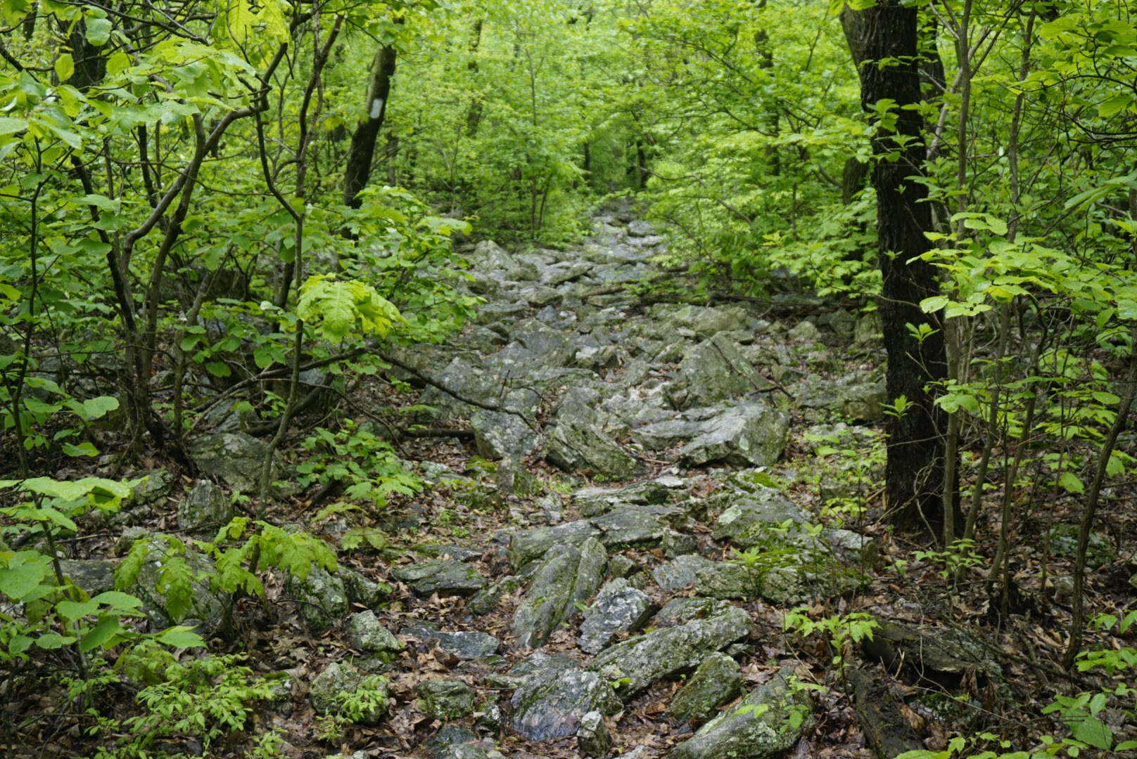
The rocks came and went throughout the day. Sometimes it was so technical I could barely move, and others the trail was flat and nicely groomed. More of the former than the latter, however, and much more to come. These sections are not only murder on my feet, but also mentally exhausting – you can’t take a second off and must concentrate on each and every step to avoid sharp edges and twisted ankles. I sometimes had to pause for a minute or two just to let my brain rest and catch up with my feet.
There were no views to speak of today, as I was mostly under the cover of the green tunnel. There were a couple of small climbs but the elevation change overall was barley noticeable with the exception of the descent into Port Clinton (and subsequent ascent leaving the town). That part was basically straight down with no switchbacks whatsoever for about a quarter mile. Luckily it wasn’t muddy like the rest of the trail or I probably would have slipped and slid the whole way to town.
Port Clinton is a tiny little town with a post office, hotel, and not much else. The trail goes through part of its, but there’s nothing to see or do so I didn’t stop. From what I’ve read, the town doesn’t even have an ATM! After heading out of town and doing the climb up, I was back on the ridgeline fighting more rocks. After a bunch of miles of that nonsense, I was blessed with some smooth trail which, although muddy, was a great change of pace.
I ended up having to do a little night hiking to make it to the campsite, where I arrived just after 9pm. Tomorrow I hope to do similar mileage, but I’ll get an earlier start.
Day 59: Campsite at mm1234.2 to Campsite at mm1265.3- 31.1mi
I had no trouble getting to sleep last night after a long day, but when my alarm went off at 5am it was a different story. I eventually got myself up, ate, and packed so I could start hiking at 6.
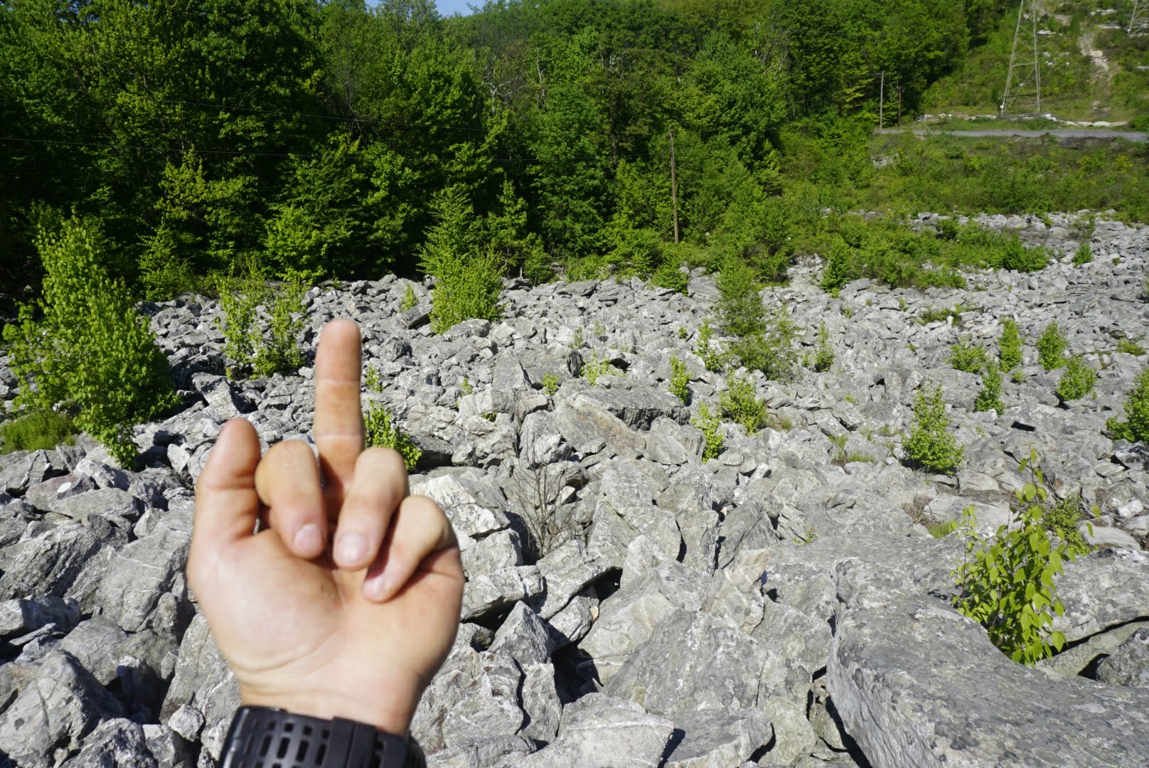
I knew I was in for a hellish day, and the trail delivered. This was, I’d say, the hardest day I’ve had so far. Although the weather was wonderful and warm, the rocks were absolutely relentless. Giant icebergs of granite filled every inch of the trail for miles, offering only a few small sections of relief with the occasional flat spot.
The day started with a relatively sharp climb, one of three I faced throughout the day. Each ascent left me atop a rocky ridgeline that required careful maneuvering and total concentration. I passed by several shelters and many good tent sites while scrambling my way across the mountains and subbing my toes all along.
One of the main concerns for the day was that There’s a point after which no water is available for over 20 miles – the longest dry stretch I know of on the trail. These mountains were used for smelting metals back in the day, so any water from atop them is likely to be contaminated. As such, it was advised to fill up at the George W. Outerbridge Shelter with enough to last. I maxed out my capacity with 3 liters and pressed on.
Soon after, I encountered the climb up Blue Mountain Ridge, which was the most intense scrambling I’ve done yet. Trekking poles were useless, so I stashed them away and took to the rocks on all fours. It took me nearly an hour to ascend, but at the top were great views of the river and town below.
By then I was 25mi in for the day and feeling spent. My feet were throbbing from all the sharp stones I had subjected them to and the sun was beginning to set. After a brief flat and amenable section, it was more rocks until I reached my destination. I finally dropped my pack at 915pm, over 15 hours after I started. What a day! There was another tent set up at the site, and I soon found out that the occupant was a hiker I had met at Rock N Sole Hostel the other day named Jelly. He had been dropped off 30mi up the trail from the hostel yesterday and I guess had done two 15mi days, which is why I was able to catch up.
I set up camp as quick as possible and laid down as soon as dinner was finished.
Day 60: Campsite at mm1265.3 to Delaware Water Gap, PA – 29.6mi
I was on the trail at 6am and the rocks started immediately without relief. I knew rain was in the forecast, and it soon started in as well. I spent almost the entire day looking down at my feet (which were slipping and sliding all over wet rocks) while the raindrops pattered off my poncho.
As I mentioned, this whole area has very limited water. There was nothing available for over 10 miles from where I started, and even when it did start showing up again the streams were over a half mile from the trail and I couldn’t fathom walking over a mile extra to get it. As such, I went for nearly 20 miles on about a liter and a half which left me a bit drained an dehydrated.
I only saw a couple of other hikers throughout the day, and I might have even missed a few just because I was so zoned out. I eventually came down into Wind Gap, about 15mi from where I started, and had my energy revitalized a little bit after seeing civilization. After crossing a busy road, there was a steep climb back onto another rocky ridgeline.
I watched the time tick by as I stumbled and battered my way along the boulders, my place slowing to a crawl. All of a sudden, I caught my toe on a stone and went flying forward, barely catching myself before smashing into a granite slab. This had happened a dozen times today already, but this time I snapped. I could feel the steam coming out of my ears as I regained my balance, and without even thinking I picked up my trekking poles and swung at a tree, wrapping them around the trunk. I hurled the warped sticks into the woods as hard as I could, then sat down in the middle of the trail and began to cry. Hiking day after day over rocks and in the rain while my feet hurt so bad I could barely stand had taken its toll. I sat there for a while, the rain running down the brim of my hat while I sputtered with frustration. When I eventually regained my composure and retrieved my trekking poles (which still work, miraculously), I continued putting one foot in front of the other as I always have. I wish I could say the rocks disappeared and the sky opened up to a sunny afternoon, but it it didn’t. The rocks continued for the rest of the day just like the rain. No rest for the weary.
My destination for the day was Delaware Water Gap, where I’d stay at the Staybridge Suites hotel. The hotel was a couple miles from the trailhead and when I arrived there at about 7:45pm it was a ghost town – highly unlikely I’d get a hitch. I decided to see if Uber would work, and I was surprised to see that it did. I was able to get a driver to pick me up in about 15 minutes and drive me the 3mi to the hotel for about $7.50. Not bad!
At the hotel I did all of my chores as quickly as possible so I could get to bed. I still wasn’t able to lay down until 10pm, but it was nice.
Day 61: Delaware Water Gap, PA to Brink Road Shelter – 24.8mi
I had a great night’s rest at the Staybridge Suites last night! I really like that chain of hotels because each room is like a studio apartment with a full kitchen, refrigerator, utensils, and dining table. They have a great breakfast buffet and also offer evening snacks and drinks (which I just missed last night). I also found out this morning that they offer free laundry – wish I had seen that earlier!
After demolishing stacks of waffles and eggs at breakfast, I went to the business lounge to use a computer and publish my weekly blog post and pay some bills. It always takes me longer than I think it will to put out the blog, but I love doing it so I don’t mind. After finishing up, I went back to the room and packed up. I hailed another Uber from the lobby and it arrived after about five minutes. The driver did a double take when I opened the door and got in. I know man, I know. Just drive.
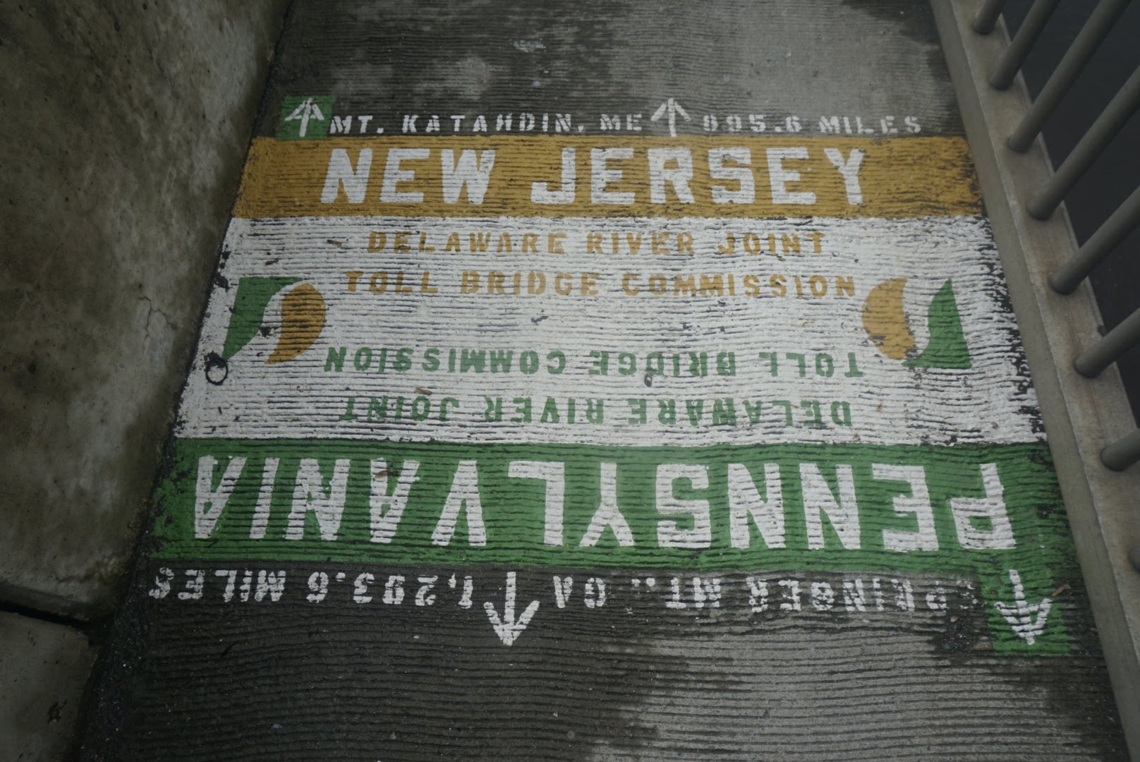
The ride back to the trail was fast and easy. The first bit of trail is on a sidewalk adjacent to Interstate 80, and after about half a mile you come to a painted sign on the ground indicating that you’re leaving Pennsylvania and entering New Jersey. Sayonara, rocks!… Or so I thought.
The trail continues on the road for another mile or so and then comes to a parking lot with a couple different trail heads. By now it was nearly 11am so I was getting a late start, but the weather was nice and I was ready to go. As soon as I set foot on the trail, the rocks appeared. They were mild at first, but grew progressively larger and sharper as the day went on. While they were indeed better than the relentless nonsense of PA, they were difficult in their own right.
There were several good sized climbs throughout the day which offered nice view of the farms and towns below. There wasn’t a cloud in the sky, either. If I’d had more time, I would have stopped for a nice long lunch break at one of them. But, alas, I had many miles to go so I pressed on.
One thing I saw today that I’ve seen nowhere else was large groups of teenagers on the trail. They appeared to be urban youth enrolled in some program (didn’t seem like the Scouts) that was requiring them to hike this section of the trail. I saw a few chaperones wearing US Navy t-shirts, so maybe it was some kind of JROTC thing. Or perhaps it was court ordered. All I know is that it was a definite “Hoods in the Woods” type of situation and these kids looked miserable. What was so strange is that I saw at least 10 different groups of them at different parts of the trail all throughout the day – I probably passed a hundred of these kids and every time I went by, without fail, I’d get asked how far away the road was. I guess they were eager to finish!
Due to my late start, I was pressed for time and didn’t feel like hiking too far into night given the rock situation. I set my sights on the Brink Road shelter which seemed attainable, and was able to get there just after dark at 8:45pm. I’m actually camped on a flat spot just before the shelter, as it required a quarter mile side trail to get there and we all know I’m not about that life.
Day 62: Brink Road Shelter to Pochuck Mountain Shelter – 32mi
Once again I was dead tired and had no trouble falling asleep but all the trouble getting up. Despite that, I was on the trail at 6 per usual.
Not knowing what the terrain would bring left me uncertain of how far I’d make it before dark, but I thought I might have a chance of making it to Pochuck Mountain Shelter, 32mi away, if I set myself to it. I’ve only hiked 32mi one other time (between Hampton, TN and Damascus, VA) and the terrain was very easy. Given the rock situation I faced yesterday, I wasn’t sure today would be any better. Long story short – it wasn’t, but I made it anyway.
As the rocks begrudgingly begin to lessen (although barely), the bigger climbs are being reintroduced. New Jersey has been like a bastard child of Pennsylvania and North Carolina – steep climbs with rocks. From what I understand, the hills get bigger in New York but the rocks disappear even more, so it’s just a matter of getting out of NJ (which I did).
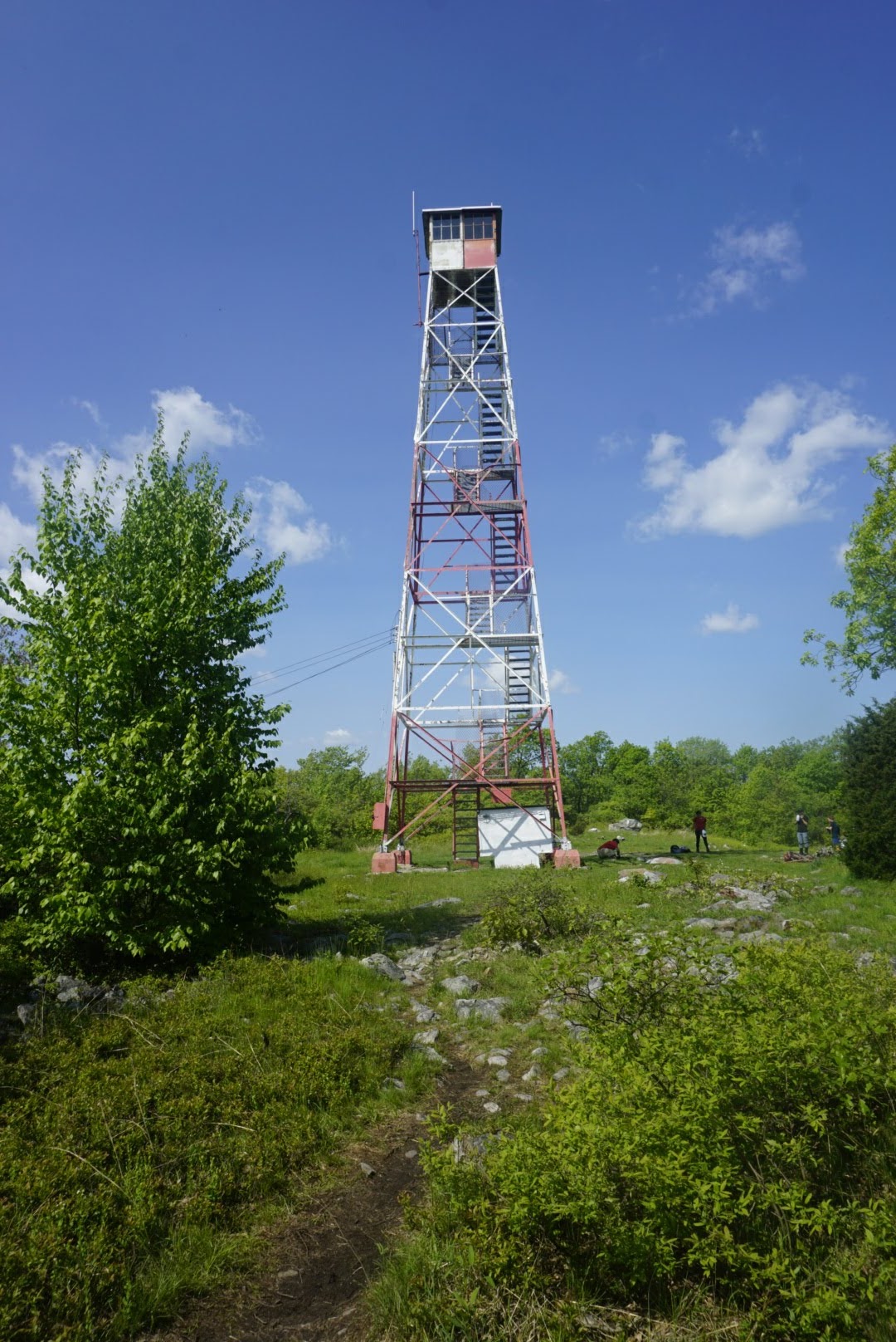
I passed by a couple of fire watch towers (Culver tower and another observation deck), but I didn’t bother going to the top of either. At this point I’ve seen so many overlooks that they start to blend with each other and I just don’t get the value from them that I did in the beginning. I’ll usually pause at a nice view for a few seconds, perhaps take a photo, but otherwise I push on.
As I mentioned there were several multi-mile stretches of rocky terrain, but it was all more hikeable than Pennsylvania. Between the rocky parts were a couple of nice cruiser sections which helped me keep my overall pace up.
My only long stop for the day was at the High Point State Park Visitor’s Center, which is just steps from the trail. I read in the comments on Guthook’s app that they give a free Pepsi to each thru-hiker, courtesy of the Friends of High Point organization, so of course I had to cash in. They also have some electrical outlets that they let hikers use to charge their electronics, which is nice.
I got my Pepsi and hung out on the grass for a while, eating peanut butter and resting my feet. About 45min later I was back on the trail to finish out the remaining 14mi of the day.
The weather was fantastic again today – cool in the morning and sunny all day without being humid. It was very rocky for a while after leaving the visitor’s center and my feet were starting to hurt quite a bit. I popped another ibuprofen and continued.
The rest of the day was quite nice and included a walk through a wildlife preserve, about a mile on the road (the most yet, I think), and only one big climb up to the shelter. I arrived at 8pm, my earliest night for a while, after 14 hours of hiking. I set up my tent close to the trail for an easy escape in the morning.
That’s all for this week!

This website contains affiliate links, which means The Trek may receive a percentage of any product or service you purchase using the links in the articles or advertisements. The buyer pays the same price as they would otherwise, and your purchase helps to support The Trek's ongoing goal to serve you quality backpacking advice and information. Thanks for your support!
To learn more, please visit the About This Site page.
