 ">
">
Out of the Sand and into the Snow
On the day that Josh and I left Ghost Ranch we dillydallied, slow to wake up, to pack, to say goodbye to friends who weren’t heading north, to leave.
The night before we both stayed up late with Wing It and Stoke, drinking and making too much noise. It was one of those nights full of strangeness for me in which things just came together. Too much beer thanks to a guy who kept talking about his 50-plus mile day exploits. A woman with a lavender farm. Two road trippers from Salt Lake City who came for a show in Taos. Lots of stars and a campfire, and then I woke up the next morning with a dry mouth as the sun rose. Was I really about to figure out how to strap snowshoes on my pack and then walk out of there? So it took a while.
I did get a new Dirty Girl gaiter along with my snowshoes! Weeks before Josh had been scrolling through the website looking for the loudest, most obnoxious patterns, and I decided to pick out new ones for myself. I saw this pattern and I knew it was the one. I had the folks back home (in this case Josh’s younger sister) send me just one to replace the gaiter that disappeared in the night.

After lunch in the cafeteria—pita pizzas and wings—Josh and I lay around on the lawn and digested for a while. As the wind picked up, we finally decided to shoulder our packs and go. A dirt road turned into single track as we traced a stream up into a canyon. Josh had seen something in a Guthook comment about a turn at a painted blue coffee can. The most worn path looked to go right, so we followed it, walking past a large pool of murky water.
“Swimming?” said Josh.
I poked the water at the edge and a plume of black silt billowed out. Maybe not swimming.
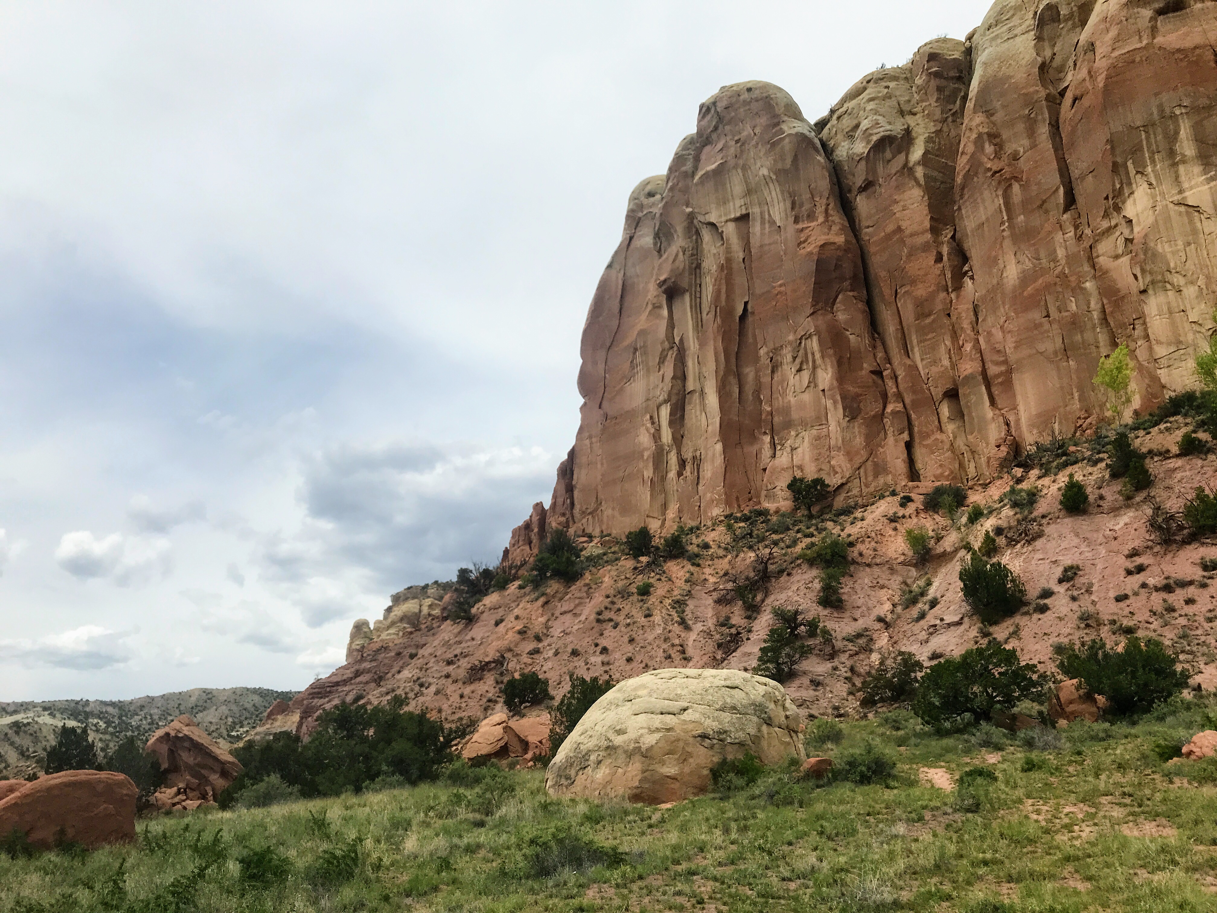
When we went a little farther and came to a dead end canyon, checking Guthook revealed that we had gone the wrong way. Once back on the actual trail we started gaining elevation and were soon out of the canyon, with views of mesas behind us, red-yellow-orange against the sagebrush and cloudy sky.
The rest of the afternoon had us road walking through forest, then trying to follow a faint trail up a ridge. We found a spot to camp beneath a large pine tree with low hanging branches. It was protected and cozy.
Right underneath a pine tree, in a hollow of soft needles, is my favorite kind of spot.
Josh and I spent the next morning trudging along muddy roads, across green hills, and through mixed pine and aspen forests. Avoiding puddles and deep sticky spots slowed us down a fair amount, and carrying pounds of extra weight on each foot was tiring. We stopped for lunch at a stream and got pelted by large hail. The weather felt sort of ordinary and acceptable, like of course we would get hailed on right now.
After lunch we started to hit more and more snow. I was feeling good about it, and I was able to run across consolidated patches without sinking in. It reminded me of the snow in the Sierra in 2017, when I was always racing to keep up with my trail family.
The trail arrived at a paved road I hadn’t been expecting, and I walked down it a bit to the Upper Canjilon Lakes picnic area.
I noticed a beer can on the ground and then realized it was still sealed. I waited for Josh and we drank the Bud Light while sitting on the concrete by the bathrooms. It started hailing again and I shouted at the sun, “Make a hailbow!” but it didn’t. We threw away the empty can in the bin and headed out across the snow.
Going through a mixed aspen and pine forest I noticed some bear tracks—not too recent, but big. Josh put on his snowshoes when the snow was no longer patchy, but I stubbornly held out. I had a dance party by myself, listening to Girl Talk on my headphones, while Josh adjusted his snowshoes.

The trail went up a stream, easy enough to follow, but we missed the turnoff and had to backtrack. I wasn’t sinking much in just my trail runners. At 5 or 6 p.m. I decided to try out my snowshoes, this being day two of carrying them. Unfortunately, this coincided with a sudden feeling of infinite hunger. There were no more snacks accessible in my hip belt pocket. Josh very generously gave me some of his snacks, but I was still starving. There was snow everywhere and we hadn’t done as many miles as we planned. Luckily we found a small patch of dirt by a tree, and Josh convinced me that it was really OK to stop. I’m glad he did, because my feet were getting very cold.
He had the genius idea of putting our quilt into a trash compactor bag so that we could warm our feet while making dinner.
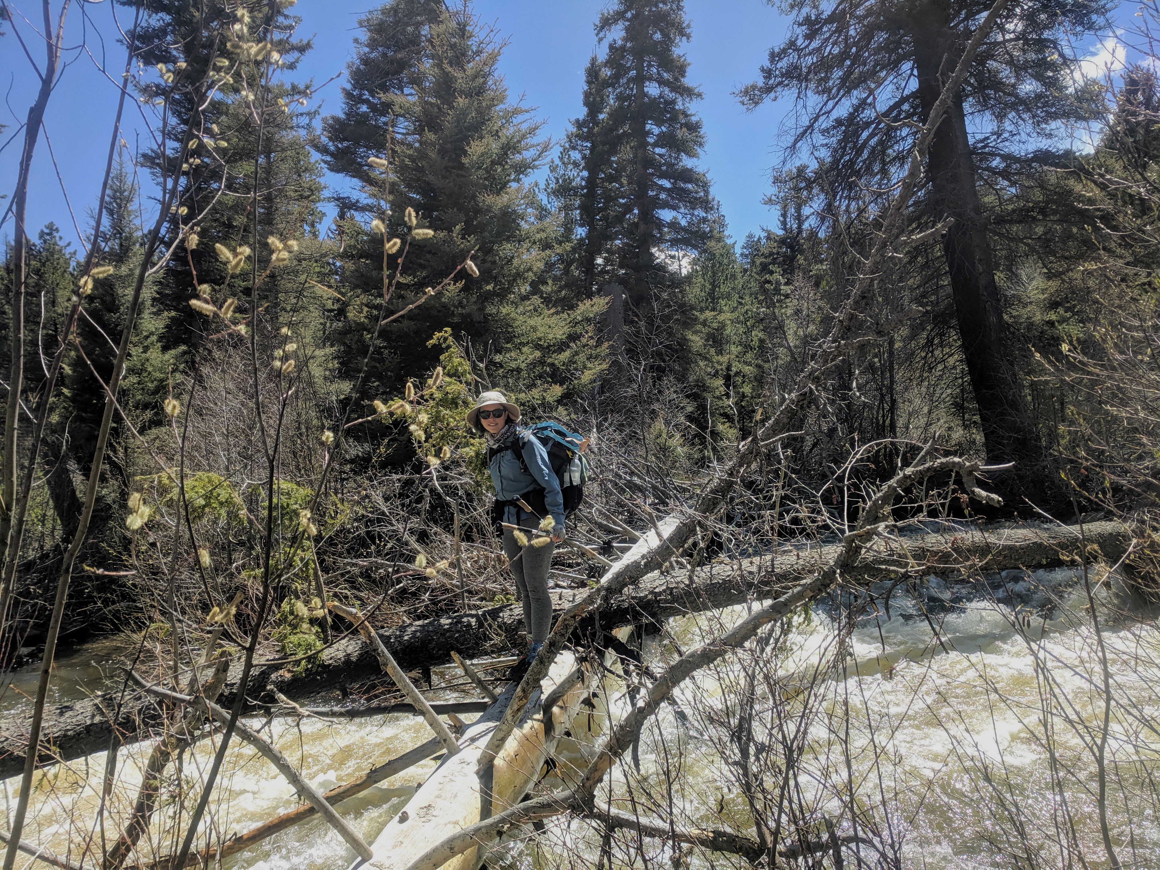
It was a very windy night, with graupel, a kind of snow that’s like tiny hail. After packing in the morning up we walked along a windy flat ridge for a while, before I led us on a “shortcut” that took us through some very wet, melty areas before dropping down to the trail next to a stream. After a couple more miles of patchy snow there were a few clear miles. We got to the Rio Vallecitos, a decently sized un-bridged river that we were worried about crossing. Fortunately there was an excellent log.
The afternoon brought more snow, but it was patchy and I got to Hopewell Lake campground without putting my snowshoes back on. Josh and I had fantasized about a lean-to and a fire pit with wood stacked next to it. We did find a wooden picnic pavilion with a locked bathroom. It was so windy and cold that we did the quilt trash compactor bag foot warming thing again. During dinner, Josh’s wet socks that he’d been wearing froze in the air where he put them to dry. The least windy spot to camp was in the small covered two-walled area right outside the bathroom.
When I woke up I peeked out of the tent and saw a brilliant, red-clouded sunrise over the lake.
By the time I got dressed it was over. Josh and I hiked on down the road talking about all the puffy warm down gear that one could buy, like down pants and booties. The paved road turned into a dirt road and then got covered by snow, which was hardpacked and I felt pretty smug as I walked on top of the snow, following a boot track of postholes. I felt less like I was beating the conditions when I skirted mud and frozen puddles between snow patches, occasionally misjudging and punching through the ice. Wet feet are not as fun when you’re not at the beach.

The weather was cloudy and windy. I found myself on a wide field, sloping upward toward the trees. I stumbled over ice and rocks for what felt like forever. About a thousand years later Josh and I had lunch perched on a log in an aspen grove. I made instant hummus and ate it with crackers; pretty gourmet. Later on we were able to dry our gear out in a grassy meadow before crossing a large creek.
I went shoe-less and pant-less because I was tired of being wet, but crossing barefoot did feel sketchy.
Up from the creek the trail went next to a steep drop with some very dramatic and crumbling rock outcroppings. The views of the ribbon of water in the valley far below were incredible. This was what I imagined the CDT would be like: walking on the spine of the continent, rivers and streams unspooling at my feet.
After gaining some elevation and crossing over to the north side of the ridge, Josh and I eventually got onto a road leading to Lagunitas Campground. The snow patches were increasing in size and frequency. The last mile seemed slow, even though we were cutting our day a little shorter by choosing to stay at the lakes. We found a bathroom with a busted open door. After checking out all of the snow-free patches I found one that was relatively flat and out of the lake’s wind tunnel.
For the third night in a row, we rushed to eat so that we could warm our freezing feet sooner rather than later. Josh carries camp shoes, minimalist sandals from Xero, that he can put on with dry socks at the end of the day. I don’t.
The wind continued to build through the night. A branch against the tent fly kept waking me up, sounding just like a mouse nibbling my white cheddar popcorn bag.
The next day was all above 10,000 feet and likely to be all snow. With 23 miles to go into Chama, Josh and I woke up before dawn and started packing up the tent as it snowed. We put away everything inside the tent fly, collapsing it last before braving the weather and strapping on snowshoes. It was just getting light.
Josh and I began to struggle our way up the hill. The trail was situated with a drop on the left-hand side and trees on the right. The wind was strong and chilling. I was wearing almost all of my clothing: rain skirt and knee-high gaiters on my lower half, puffy and rain jacket over my hiking shirt, buff tucked under my hat covering my neck and ears. I was still cold. We retreated into the trees a couple of times to eat bars and check Guthook to make sure we were on track.

The hill flattened toward the top and we began forging through the trees, attempting to walk in a straight line, but weaving to avoid where the snow had piled of thickets of young pines blocked our way. Josh and I were continually having to check our navigation.
Finally, we were rewarded by open spaces. It was still snowing, but the wind wasn’t as bad.
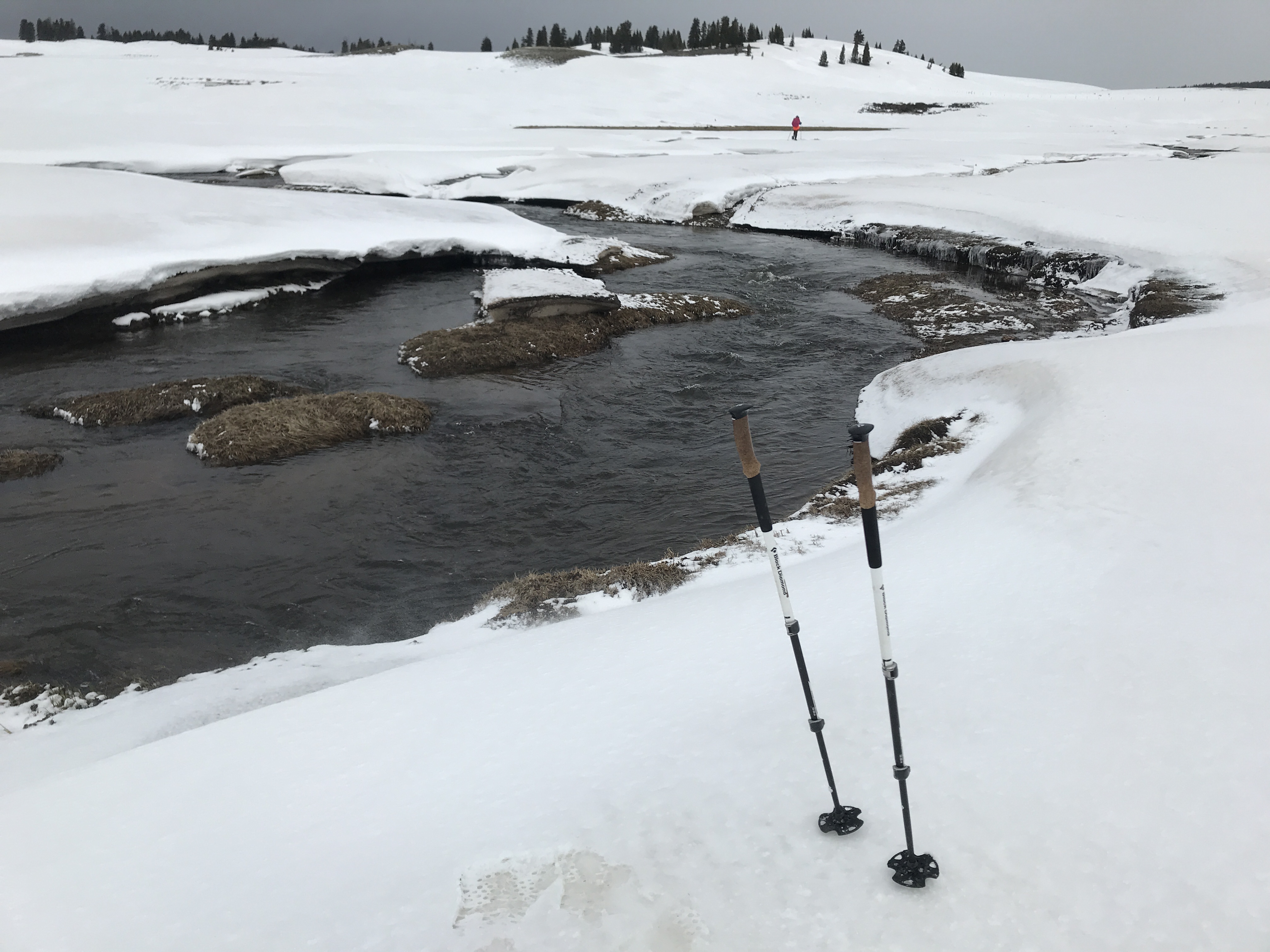
I noticed snow that had been cross-loaded by the wind into long pillows. For now the trail was on lower angle slopes, but I worried that steeper slopes could present avalanche risk if enough snow fell.
Having packed out very little water from Lagunitas, we decided to take a road down into a valley at lower elevation. There was no water flowing up on the ridge, but our alternate took us down to a stream fairly quickly. Walking on the road was much easier, as we could tell where the cut-out was, even in the snow.
At the bottom of the valley ran a melt-swollen creek. I managed to cross without going deeper than my ankles, a victory considering how cold the water was!
After cresting a hill on the other side it became too foggy to use the ridges around us for navigation. We had to pick nearby patches of trees to walk toward. Through the fog Josh saw a cabin and I decided that if they had a light on we would go knock and ask for a hot drink. It turned out to be boarded up for winter, still.
We reconnected with the CDT. The fresh snow continued to build up. I measured the fresh powder every hour or so, and there were more than six inches by midafternoon.
We reached the official CDT high point of New Mexico—just over 11,000—and hurried on toward the Colorado border.
My gloves had soaked through and were freezing at the tips. As Josh and I traversed a steep diagonal downhill slope, pushing our snowshoes’ abilities, we had to take a couple of breaks so that I could warm my fingers.
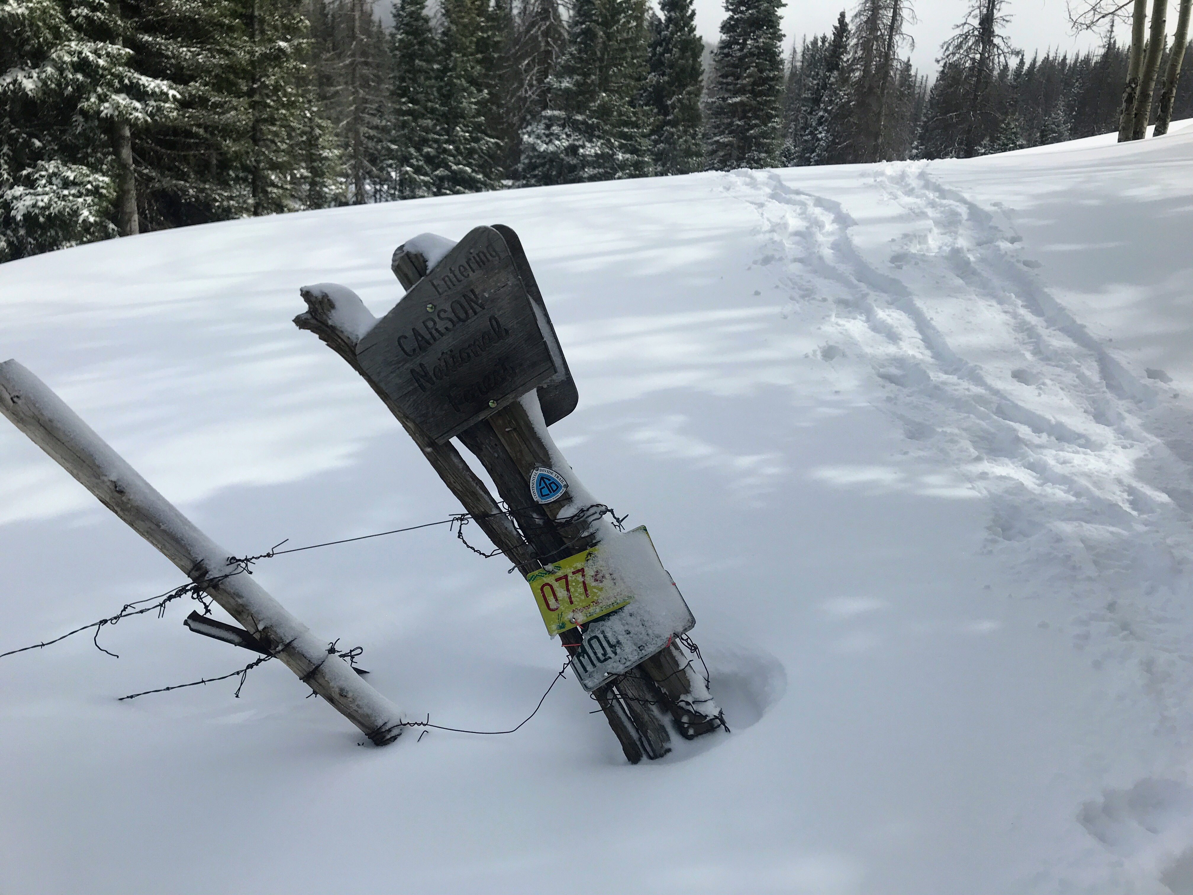
Finally, we got to the last small climb into Colorado! The sun began to peek out from the clouds, I followed Josh to the top, and over the ridge was a whole new state. A national forest sign with license plates from both New Mexico and Colorado marked the border.
 It felt very exciting, but as I looked north toward the South San Juans, I felt apprehensive about the challenges to come. The whole day had felt like winter. I came out here to hike, not to mountaineer. For one of the only times in my life, I was looking at snowy peaks and I wasn’t sure I wanted to go into them.

This website contains affiliate links, which means The Trek may receive a percentage of any product or service you purchase using the links in the articles or advertisements. The buyer pays the same price as they would otherwise, and your purchase helps to support The Trek's ongoing goal to serve you quality backpacking advice and information. Thanks for your support!
To learn more, please visit the About This Site page.
