 ">
">
Glen, Pinchot and Mather Passes
Prologue
On our way out at Kearsarge Pass, we saw people we knew heading back in to make the trek to Bishop Pass. This planted the seed, but by the time we got to Bishop town, we were already considering the return.
Mini Chimi decided to flip to Truckee, and Mantis and Journey Man had a flight to catch in a week for a graduation and wedding. They decided the margin for error was too tight to risk the return to the Sierra, which was good foresight. The trip was planned for five days, but conditions made it six.
Glen Pass
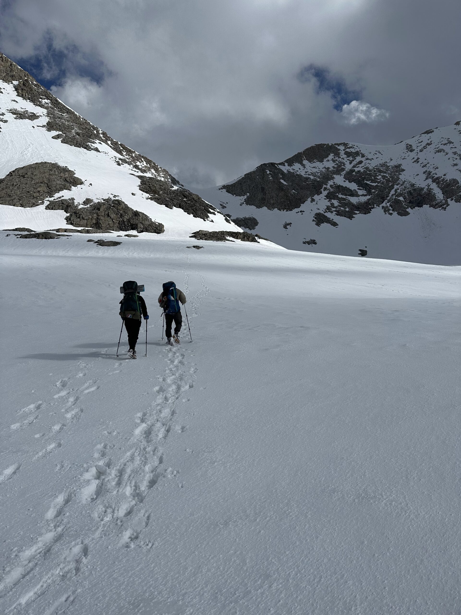
This leaves Head Start, Dash and me for the return into the Sierra. We camp at the still-closed Onion Valley Campground on the first night, and leave at 2:00 a.m. for Kearsarge Pass. It’s a longer climb than I remember, and the snow is a bit soft both up and down. This makes for a tough ten miles to PCT mile 791, with plenty of sliding and postholing.
On the second day, we depart at 2:00 a.m. for Glen Pass, 1.3 miles ahead. There are a couple of false summits, but we had heard of them in advance so aren’t let down at their crests.
The full moon is out, making it almost feel like daylight in the snow. We approach the pass from the left. The traverse is steep and sometimes soft, so each footstep has to count. In one stretch there are boulders lying a hundred feet below, which add to the stress of making the footing sure.

Head Start and Dash coming up Glen Pass in the moonlight
Eventually we come to a series of rock piles that we are able to scramble up and pause upon before starting each of the next traverses. We island hop a few times and finally come to the dirt switchbacks leading to the pass. It’s 4:30 in the morning.
One down, two to go.
Pinchot Pass
In order of difficulty this year, people are putting Forester and Mather at the top, with Glen next and Pinchot the easiest. Glen Pass took some time, so we are content to camp at 8,500 feet in the valley and leave seven miles for the morning.
We depart at 1:00 a.m. The first mile is mostly snow free, but the trail is often immersed in melt-off water. We rock hop our way up the hill. Once we reach the snow, it is intermittently slushy, suncupped, and postholey. There is a steep traverse two miles in that drops to rocks and raging Woods Creek, and self-arresting success is unlikely. You guess correctly that we take that part slow too.
Where the other passes may be touted for their thrills, Pinchot in a snow year is all about the work. The pass is at 12,127 feet, and our footsteps have been sinking in as far as perhaps 11,500. This makes the effort more substantial, and we complete the seven miles to the summit in 7.5 hours.

On top of Pinchot
It’s rather windy at the top, so we don’t bask in the moment for long. We put in some extra work on the back side and make it a thirteen-mile day to set up a four-mile approach to Mather, the most daunting pass of the three in this section.
Mather Pass: The First Try
We’re walking at 1:30 a.m., wanting to get to the base at the first light of 4:30. The snow is again soft but we manage to get 1.5 miles done in an hour. Light flurries of snow dance in front of the headlamps, in case we didn’t already feel immersed enough in the endless whiteness.
At 2:45 a.m. and 11,000 feet above sea level, we pause for water and a snack. Then there is a flash. Twelve seconds later the sound of thunder rumbles through the darkness. Dash does some math.
“Three or four kilometers away,” he says. We all just kind of stand there silently, hoping it’s nothing to worry about.
Flash. Six seconds. The snowfall begins to increase.
By the next flash followed by three seconds, we are making our way to lower terrain–near a tree cluster for wind shelter, but not too near for fear of lightning hitting a tree.
We shed our poles and axes (but not the crampons, fingers crossed the lightning doesn’t care about that piece of metal). Plopping down on the snow, we squeeze together for warmth.
Flash, thunder. It’s pretty much on us, and the snow turns to hail. Head Start pulls out the ground sheet for her tent and we clutch it over our heads as a tarp. Our legs and feet stick out from under the tarp and the pea-sized hail torrent stings through our pants.
For the first few minutes, we make jokes and laugh about our situation. The flashes of lightning are every ten seconds now and there’s no bother counting the constant thunder. As we realize the storm is stalled above us, the small talk ceases and we just hold each other tight.
Perhaps thirty minutes later, we can start to discern that the storm is moving on. We decide to frantically make camp and get into our bags as quickly as possible to warm up.
At 5:30, after a shivering rest, we talk from tent to tent, trying to decide what to do. Checking some weather on the Garmin and acknowledging none of us can feel our toes yet, it’s determined we’re waiting an hour more before venturing up to the base of Mather.
At 6:30, we’re starting to talk ourselves out of making the attempt today (worrying about what new snowfall may have done to the pass) when we hear voices in the distance.
Mather Pass: The Second Try
A group of four comes into view, and a man named Screagle (short for Screaming Eagle) comes over to chat. They’ve come straight through from Kennedy Meadows, and broke camp just after the storm.
“Come join the fun!” are his departing words as he turns back up the mountain.
Knowing there will be a group ahead of us stomping the fresh snow out of the boot track is enough to tip our scale. A moment later we’re out of our tents. As we’re packing up, Ash and Bubbles come walking by in snowshoes. We had seen them going in at Kearsarge and haven’t seen them since.
Approaching Mather (credit Jacob Sims)
Full of confidence with two groups ahead of us, Dash, Head Start and I glide up the last 1.5 miles to the base of the final ascent. Despite the earlier ordeal, we are all smiles when we take a pause at the bottom.
The climb starts with a “ladder” kicked into the snow which traverses to the right after 50 meters or so, where the path leads to rocks. This is already feeling familiar after the island hopping at Glen Pass.
After several minutes climbing over boulders, we arrive at another ladder and traverse. I can see that after this next 100 meters, we can mostly make our way on the rocks.
“This looks like the hardest part of the climb,” I call back.
The ladder is manageable but the traverse reminds us of the scariest moments of Forester Pass. There are about five times that I have to put my weight on the pull of my sunk-in ice ax in order to make the next lateral step. If the snow gives way…

Dash making his way to the rocks
All safely reach the next rocky section in the end, and the rest of the climb is an hour of bouldering. It turns out to be quite fun. As we hop onto the corniced pass from the rocks to the left, we whoop into the valley before a warm group embrace.
The Cliff in the Dark
We get part way down the descent from Mather Pass but are ready to camp sooner than later. The next morning we depart at 2:00 a.m. for the Bishop Pass trail junction.
On the way down, we are following boot tracks in the dark and quite pleased with our pace. There are some steep traverses and downward ladders that rival the passes. We’ve had good practice, so make it through these slowly but unphased. Then we lose the trail.
We’ve come to a cliff edge and have two options: strenuously go back up the way we came or go down the cliff in the dark.
Having not died on Mather and now considering myself a bouldering expert, I obviously vote to go down. I can see a route that looks good for at least two-thirds of the drop, and tell Dash and Head Start that “there’s always a route once you get there.” (Bouldering expert speaking, you know).
So down I go. There is water flowing all around down the rocks, making it a wet experience. It crosses my mind that the dark and wet conditions aren’t ideal for what I’m doing, but I’m already halfway down so what can you do.
I get down to that bottom unknown section and do well enough until the last five feet in which I have to kind of dangle and jump to the scree below and hope to not turn an ankle in my crampons. Oh yes, I’ve been wearing crampons this whole time.
“How was it?!” Head Start shouts down from fifty feet above.
“It was challenging, but, I mean, I made it down!” I call back.
“Can we make it down?!” She responds.
*ten seconds*
Again, “Can we make it down?!”
“I’m thinking!”
This does not do well for the confidence of my trailmates above, but eventually they decide it’s better to risk the descent than to back track up the icy hill and go around the long way. I help catch them on that last leap at the bottom, and we are off again towards our exit.

Dash coming down the cliff (credit Allison Frelinger)
Finally a Flip
The Sierra section to Bishop Pass in a year like 2023 has been a highlight of my life. I never dreamed I could hike and camp in the snow for 14 days and overcome dangerous passes soaring above 12,000 feet. Words can’t describe the pure elation I have felt standing at the tops of these passes with my trailmates.
Nine of us went from Kennedy Meadows to Lone Pine. Six of us came back and went as far as Kearsarge Pass. Three of us have gone to Bishop Pass. I intend to return with Mantis and Journey Man (and probably Head Start) in September with my “plan B” JMT permit from Kearsarge to Yosemite, so we’ll all get to do a few of these passes again, fire season permitting. Maybe even swim in the lakes instead of walking on them.
With the melt finally starting to crescendo, it’s time to flip a little bit ahead. Head Start and I will be joining Mini Chimi somewhere around Old Station in a few days, and Journey Man and Mantis will be a couple of days behind us. Lizard King and M. and Sheriff may also be plus or minus a day. Dash, however, plans to go back into the Sierra for now and find us later.
We are no strangers to snow, and there is plenty ahead. But we are excited to see our other friends again and ready for whatever comes next.

This website contains affiliate links, which means The Trek may receive a percentage of any product or service you purchase using the links in the articles or advertisements. The buyer pays the same price as they would otherwise, and your purchase helps to support The Trek's ongoing goal to serve you quality backpacking advice and information. Thanks for your support!
To learn more, please visit the About This Site page.

Comments 3
We drove up 395, coming from Joshua Tree National Park and going through Susanville on our way home to Portland in early May. I lived in the Tahoe area for 30+ years. I would never have thought anyone could do these sections of the PCT this year, as I have never seen snow in the Sierra like this since I first moved to the area in 1977. I am in awe of you guys for being able to do this. Good job, and your accounts are riveting!
Amazing pictures and stories! I love hiking in the Sierra, and can’t imagine doing it in these conditions.
Wow Scott! Great times & challenges make never ending memories and lifelong friends. Great pics and writeup!!
Wishing you a safe journey onward