 ">
">
AT Days 48-51: Killington Conquered by Deli Sub
Nothing fires up a thru-hiker like access to “real” food. A fresh deli submarine sandwich helped me conquer Vermont’s Killington Peak, the highest mountain thus far on my AT journey. Here’s the daily summary, all locations in Vermont:
Day 48 – Minerva Hinchey Shelter to Churchill Scott Shelter (19 miles)
Day 49 – Churchill Scott Shelter to The Inn at the Long Trail (4 miles)
Day 50 – The Inn at the Long Trail to Stony Brook Shelter (8 miles)
Day 51 – Stony Brook Shelter to Thistle Hill, VT (22 miles)
Equipping Myself for a Big Climb
As Day 48 dawned, I was excited to be tackling my first 4000-foot mountain of the hike, Vermont’s Killington Peak. As I’ve noted in my early blog posts, the bulk of my hiking experiences involved climbing the 4000-foot peaks in New Hampshire’s White Mountains. Oddly enough, I’d never scaled a 4000-foot Vermont peak in my hiking past.
I’d enlist a secret weapon to help me conquer the peak: a delicious “Kerwin” submarine sandwich from a deli just off the trail on Route 103. Positive hiker comments abounded, so I’d visited Goucheberg Farms Market and Deli last year at the end of my Vermont shakedown hike. Therefore, I felt well justified in walking the extra 0.8 road miles each way on my AT hike. I’d also pick up a fresh nine-ounce bag of Fritos (yum!).
But before I could take that road walk, I’d have to cross the deep river chasm known as Clarendon Gorge on this bouncy wooden footbridge:

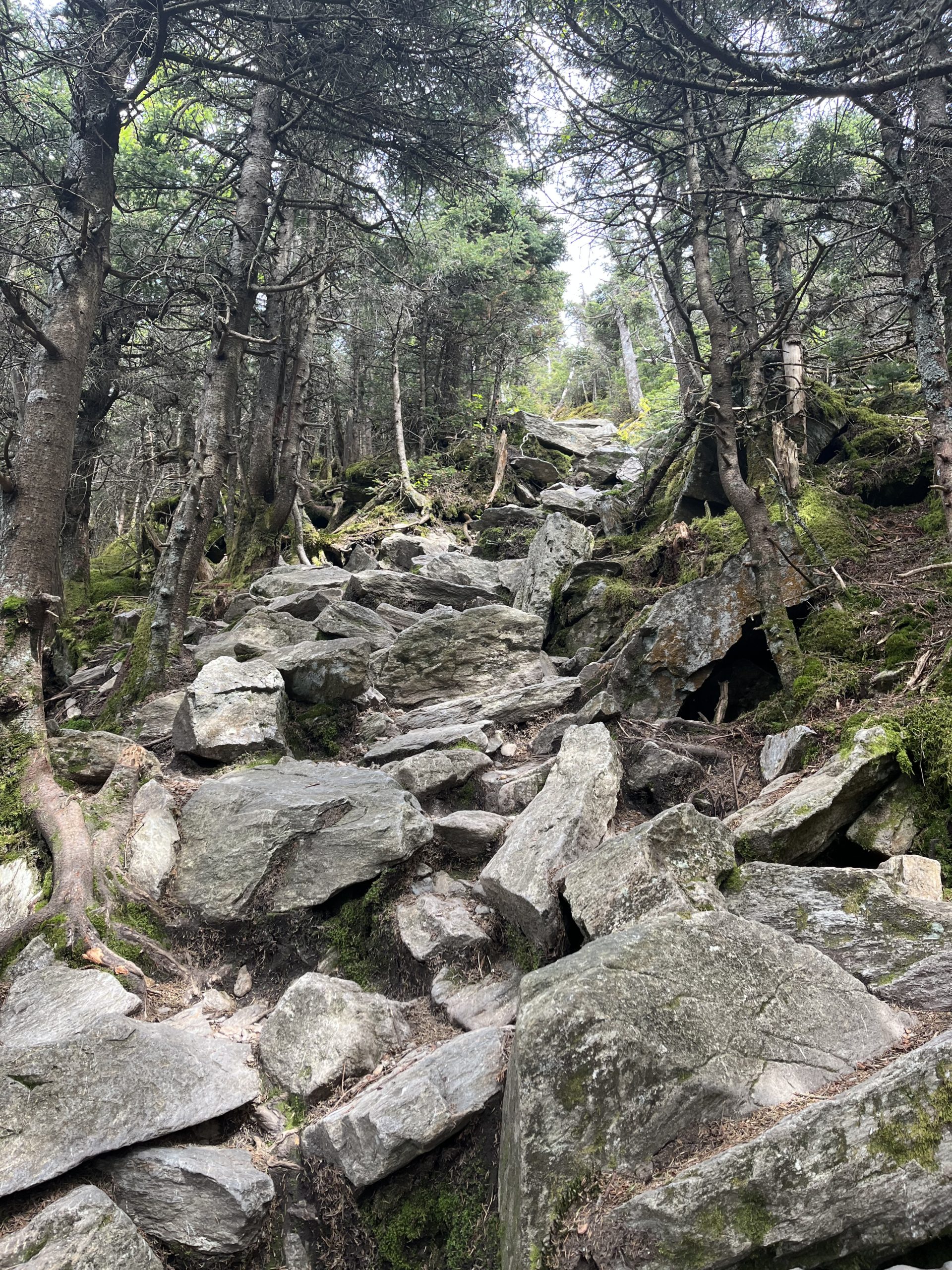
Back on the trail, the initial terrain on the north side of Route 103 had some huge rock crags and tough climbing. Clearly, this was a bit of foreshadowing of the tough climb to come over Killington Peak:

A steep section after the Clarendon Shelter brought me to Beacon Hill. This is one of the few trail signs I’ve ever seen that specifies a time for a hiker’s arrival. (Well, that’s a bit of pressure that no one really needs, now, isn’t it?) Oddly I found no Massachusetts lawmakers, golden domes, narrow streets, or terribly overpriced 400-square-foot apartments! Hmm… I guess all Beacon Hills are not alike, are they?

I was so eager to devour my special food that day that I crafted a Weird Al Yankovich-esque song about it as I was grinding my way towards Killington. Sung to the tune of the Bad Company classic “Ready For Love”, here are my lyrics to “Ready For Lunch”:
Deli sub I got this morn’
Better food than I’ve been eating
You should know … how it’s gonna end
Fritos in my pack again
Corn chips oh so crunchy, tasty
They will go … in my mouth again
Oooh I’m hungry today-ay
Oooh I’m hungry I say-ay
That I’m ready for lunch
Oh baby I’m ready for lunch
Ready for lunch
Oh baby I’m ready for my lunch
I’d eventually choose the Governor Clement Shelter as the place to devour my Kerwin sub. Oh man — two bulging halves of roast beef, bacon, lettuce, onions, and chipotle mayo — it was a lunch that would launch me to new heights. Unfortunately, I ate it so fast I didn’t even get a picture for you. But I got you all a Fritos pic -it’s one of the densest foods out there, and incredibly tasty:

The Killington Fight
I was eagerly anticipating the ascent of Killington that day because it was a MOUNTAIN, a 4000+ peak that I knew would be a physical battle.
Something primal kicks in for me when hiking to the summit of a big mountain. I hungrily crave the part of the climb where it becomes a challenge of my will. And thus far on the AT, I wasn’t getting that from these 1500-2000 foot hills. You know what I’m talking about, fellow hiker:
- The introductory “easy walk” and friendly switchbacks are long gone
- You’ve worked up a good working sweat for a long while as you grind higher
- The fresh legs you brought to the mountain have long grown stale
- And the MOUNTAIN is bringing it to you – straight up steep, maybe some ridiculous rocks to conquer
This is truly the time I love on a hike. Bring it on. I came here to compete. Man versus mountain. Mano a montana.
Killington threw the steep windswept ridge at me, roots and rocks aplenty. But I kept driving on. The wind roared furiously and relentlessly through the short evergreens. I kept pressing higher. The mountain got me really good once – tripping on a root, I cratered to one dirty knee but pushed on, gasping. My heavy pack nearly pressed my face into the soil. Ha – not dead yet.
Eventually, the trail turned off the ascent and let to a flat, calm ridge walk. I knew then that the fight was over, another MOUNTAIN subdued. Sub-dued, in this case (ha ha).
But that summit climb!
From an AT perspective, the Killington climb is done when a thru-hiker reaches Cooper Lodge. This decrepit shelter sits at the saddle of Killington ridge, below the actual peak. The NOBO AT heads downhill from this point. But I wasn’t about to pour out that much effort on a hike to not take the true summit, which was a mere 0.2 miles away up a steep trail. So, dropping my pack at Cooper Lodge, I took only my poles up the spur trail to get to the peak summit.
And what a 0.2 that turned out to be! I’ve climbed all of the steep pitches in New Hampshire: Huntington Ravine, Kings Ravine, the Wildcat ‘E’ wall, the Tripyramid slide — but this climb was like scaling a chimney! Straight up, foot to hand to foot:
And the view turned out to be well worth it – though I could also tell that rain was imminent:

Reunions and Departures at the Inn
The Inn at the Long Trail sits a very short distance from Maine Junction, where the AT takes a right turn towards Maine and the LT (Long Trail) takes a left turn towards the higher Vermont summits and Canada. My well-planned 4-mile nearo day worked to perfection, as the hiker-friendly Inn let me check into my room very early so I could board a free bus to Rutland to do resupply. Rutland turned out to be a wonderful stop, as I had a second breakfast at The Bakery while a southern-tilted alt-rock soundtrack poured into my ears courtesy of the Black Keys, Alabama Shakes, and Nathaniel Rateliff.
Back at the Inn, there was lunch, re-packing, showering, and laundry to do — when suddenly, Chris, my LT friend from the first three Vermont days was standing in front of me at the front desk.
“Daria and I didn’t think we’d get here, or be able to get a room – but it appears we can get in. By the way, she kept the name Suncatcher. It’s awesome to be here!”
And it did turn out to be awesome. After I brought my laundry back to my room and repacked my bags, I headed to the pub where all of us hikers watched the Celtics-Warriors Game 3 at the bar. We swapped hiker stories and thoughts late into the evening, accompanied by my friends Fiddlehead and Guinness.
But – in a way, it was the best of times and the worst of times. (Hey, that’s pretty good – someone prolific should put that in an epic novel.) That’s because our ranks would be splitting tomorrow, with some of us headed to Maine on the AT and others headed on the LT to Canada.
Before I turned in for the night, I had a serious conversation with my friend Chris. If he was going to thru-hike the LT, he clearly needed a trail name. I told him that I thought his name should be somehow tied to his easygoing nature. An earlier hiker I’d met had been deemed “Big Easy” – but Chris didn’t fit the “big” part of that. His name did need to be tied to his easygoing nature, which was delightful and effusive. I suggested that because he took everything in stride that he should adopt the trail name “Stride”. He liked it instantly (and Daria agreed), and I’d granted my third trail name of the trip!
As I hung out as late as possible on the rainy morning that followed our fun night at the Inn, I was pleased to catch Chris (now “Stride”) on the way out. We shook hands and exchanged phone numbers to keep in touch. I hope he’s doing well on the LT. He was great company, and I wish him all the best.
The Post-Killington Landscape
I only took on an eight-mile journey on the rainy day that followed the night at the inn. My Day 50 MMM (Most Memorable Moment) clearly was the visit to Thundering Falls, Vermont’s highest waterfall. With the new rain added from the last 12 hours, there was some serious thunder coming down that slope.

This short journey involved only one steep climb: a 1300-foot ascent over a nameless peak. But somehow, this effort turned out to be brutally intensive in the rain that just wouldn’t go away. The rain didn’t stop a small bear cub from crossing the trail in front of me as I was about two miles from the shelter. I started my bear yelling “Go away, Mister Bear” – really hoping that Mama Bear was not following closely behind. But she wasn’t. Just another day on the trail for a thru-hiker.
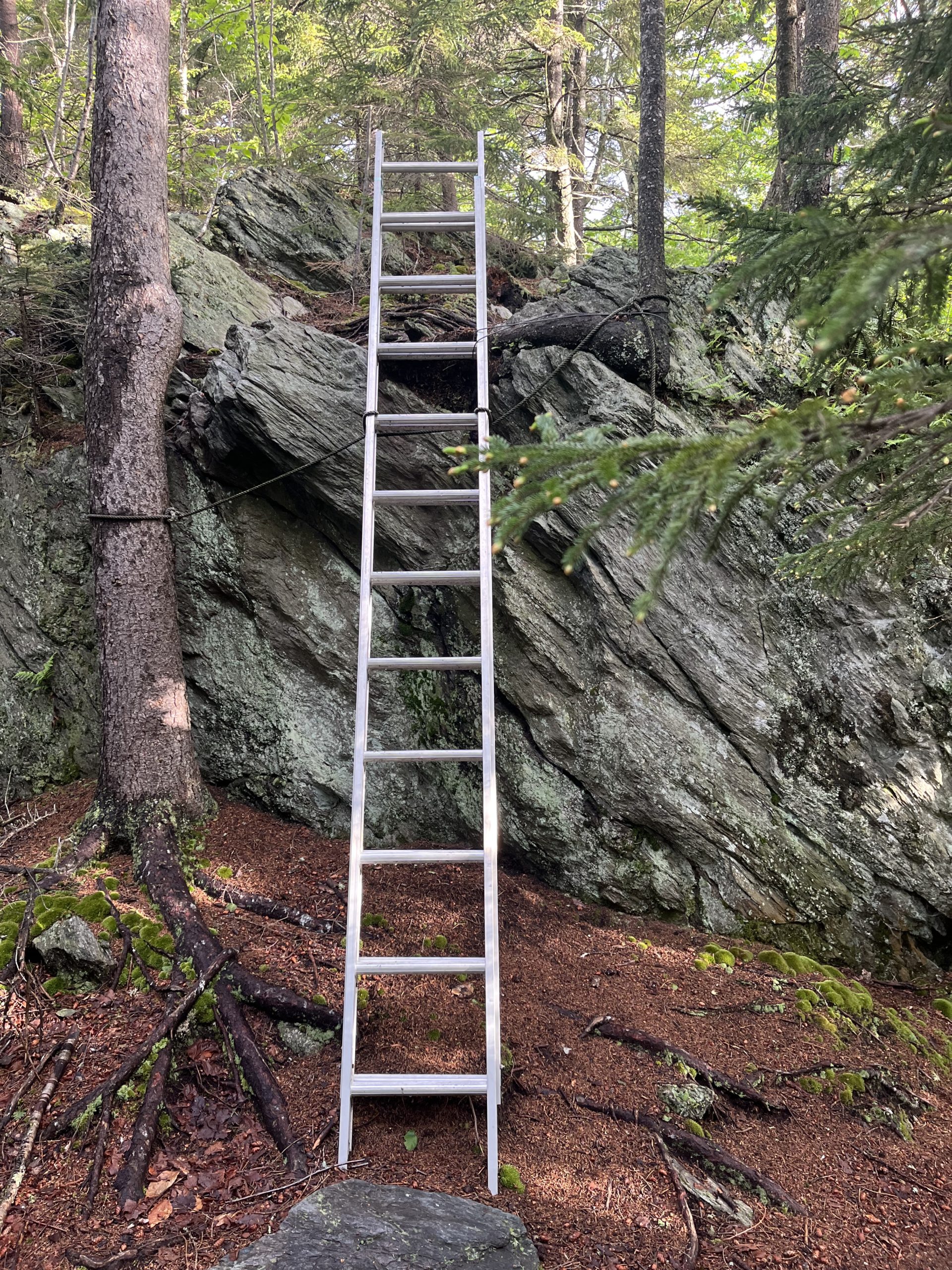
On Day 51, my final full day in Vermont, I’d tackle a 22-mile course with a bullseye target on the On The Edge farmstand, which offered fresh pies and baked goods, ice cream, and soda. This was a full 13+ miles from my starting point – but I’ve already told you what fresh food can do to a thru-hiker’s motivation! Along the way I’d see some truly strange things, like the first metal ladder I’ve ever seen on a hiking trail in my 50 years of climbing:
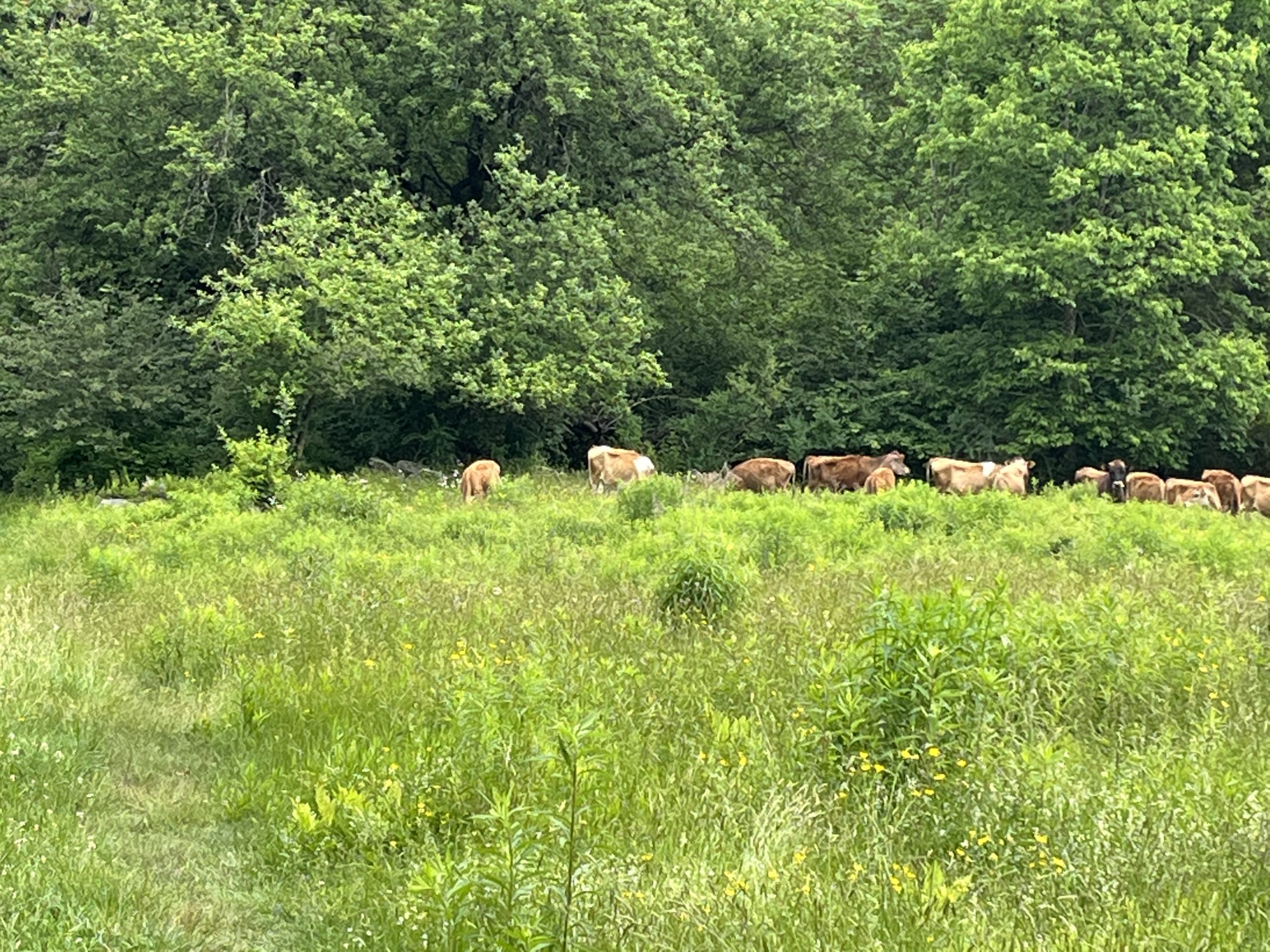
And I was also forced to cross a fence with an “Electric Wire” sign, followed by confronting a group of mangy cows. (I don’t know which was worse – maybe the cows were worse, with the electric fence it was simply binary- I was fried or not!). The cows’ stares were ominous and disturbing. I was really happy to leave that field.

When I ultimately reached the mythical farm that offered “real” food, the payoff was tremendous:

When the payoff is a fresh cranberry-orange muffin and two ice cream sandwiches with a soda, that is SUCCESS on the trail. The last part of the day’s hike involved a walk through shoulder-high pasture weeds. Yes, that’s a trail in front of you:

I will tell you – more often than not, when walking through open fields of weeds like this I will suddenly find myself singing Joe Walsh’s “Rocky Mountain Way.” It is, without a doubt, a fantastic rock anthem that holds its own weight. But I couldn’t figure out why it popped in my brain continuously in an open field. Until — I realized there was a lyric — “out to pasture, think it’s safe to say, time to open fire.” So the subliminal brain leapt over anything that the active brain was processing. Amazing.
I’d be overjoyed to arrive at the beautiful Thistle Hill Shelter at the end of this long day. It was beautiful and restful.
More to come as I’d cross into New Hampshire the following day!

This website contains affiliate links, which means The Trek may receive a percentage of any product or service you purchase using the links in the articles or advertisements. The buyer pays the same price as they would otherwise, and your purchase helps to support The Trek's ongoing goal to serve you quality backpacking advice and information. Thanks for your support!
To learn more, please visit the About This Site page.
