 ">
">
Hudson & Housatonic Highlights
Last time I wrote, I had just entered New York. Today I’m in Massachusetts! The states have been flying by in this part of the trail.
To put things in perspective, consider the twelfth-points I’ve been using as major milestones. The first two were in Tennessee (one on the NC border), and three were in Virginia. Two more were in PA, and then they start skipping states. The two-thirds point is on the NY/CT border; the three-quarters point is in Vermont. After that things will settle back down, with five-sixths in New Hampshire and eleven-twelfths in Maine. So this part of the trail may be full of state-line milestones, but that’s just because the states are all really close together.

Celebrating the two-thirds point near the Connecticut border!
Speaking of milestones, I’m now over two-thirds of the way to Katahdin! Woohoo! That means that from here on out, I have less than half as far left to walk than I already have. And as if to reward me for having made it through the Middle States, the trail’s been wilder, higher, and more scenic than it has been for hundreds of miles. Massachusetts in particular feels like the gateway to new heights, a world of northern crags that’s different from anything further south.
I’m here to write about my experiences in New York and Connecticut, though, not to speculate about what lies further north. Here are seven highlights from the past long week of walking.
1. Squeezing the Lemon
My zero day in Greenwood Lake was just fantastic. The ice cream at Bellvale Farms Creamery couldn’t have been better, Lake Lodging was a super nice, hiker-friendly motel, and on top of everything I was invited out for a boat ride on the lake (thanks, Einstein)! But all good things must come to an end, and on Sunday afternoon Andrea dropped me off on Bellvale Mountain to keep on trekking north.
Sooner than I expected, the trail plunged down off the ridge, heading east through a wilderness of lakes, bogs, and low jagged ridges. The trail was poorly marked, with forest paths branching off in many directions. Near Mombasha Lake, I got so turned around that I walked half a mile in the wrong direction, only noticing my mistake when I realized the path was too close to the water.
After many miles of clambering through waves of bedrock, the trail finally plunged down to the Ramapo valley, where the Thruway snakes up north to Albany. On the other side was Harriman State Park and the ‘Lemon Squeezer.’ The first named crag of the north, this is a narrow cleft between boulders through which the trail climbs up, followed by a tall rock face that you need your hands to scale. It’s merely the most challenging of a whole series of cliffs, guarding the edge between peak and bog on each hill along the trail. Personally, I thought it was kind of fun.

Heading into the lemon squeezer. I just barely got my pack through on my back!
That night I stayed near the shelter on Fingerboard Mountain. Whippoorwills flew back and forth on the mountaintop, and the sky was clear. Despite reports of bears, none appeared. In the morning I started fresh and ready to cross the Hudson.
2. Bear Mountain Bridge
Harriman had a few more rocky hills to throw my way, but eventually I made my way down towards the Palisades Parkway and Bear Mountain State Park. The trail has been rerouted here, after a hiker was killed crossing the parkway last fall, but very few people seem to be following the detour. I encountered my first rattlesnake of the trail near here, a dark-hued timber rattler that was curled up next to the path and didn’t notice me as I hurried by.

Looking back over the highlands from Black Mountain, the last peak in Harriman State Park.
Bear Mountain’s a prominent peak overlooking over the Hudson River, traversed with paths well-trodden by generations of New Yorkers. As soon as I started the climb, I felt like I was in a city park. Families and groups of friends strolled down the gravel paths, dodging joggers and taking selfies with every rock. The view from the top was dramatic, with the New York skyline hanging in the middle distance as the river rolled away. You could almost see West Point a few miles upstream.

The view down the Hudson from Bear Mountain.
I hurried downhill after taking in the view, hoping to get to the zoo before they closed. This ‘trailside zoo’ is one of the odder attractions on the Trail, and though it was closed for construction I’d gotten permission to walk through that afternoon. Thanks to a delay at the Bear Mountain Inn for lunch, it was a few minutes after closing when I arrived, but I was still able to go in and take a look around look before I crossed the river. The enclosures were all empty, except for one muskrat, who was busily chewing some leaves in the corner of its pen. All in all, I’m glad I had the chance to walk through.
Next came that most momentous occasion, the crossing of the Hudson River. Since the course of the Hudson is a tidal fjord all the way up to Albany, it’s at sea level here at the Bear Mountain Bridge. That makes its crossing the lowest elevation of the whole trail. Of course, the bridge is 150 feet high, so technically the zoo is the lowest point at 124 feet. It all depends what you count as the ‘real’ elevation. Either way, the river crossing is a very dramatic event. The Hudson’s as wide as the Susquehanna but much, much steeper. Sailboats can be spotted down below, while cliffs and mountains loom on either side.

Looking up the river from the bridge.
I hadn’t given much thought to where I’d spend the night, so when I learned that a Catholic retreat center a few miles away allowed hikers to camp in their ball field, I headed over there. The baseball field’s been set up as a hiker camp for decades, complete with picnic tables, portopotties, and a gravity shower.
As I arrived it was getting dark, and some hikers were hanging out around a fire. I’d met one or two of them before, but they all knew each other very well. I soon realized they were the ‘February bubble’ or ‘pod’ I’d been hearing about since Virginia. Somehow they’ve managed to keep pace for more than a thousand miles, without even trying to stay together as a group! There’s about thirty people in this miniature bubble, and I’m still crossing paths with them days later. For all I know they’ll stay nearby through Maine.
3. Deliblazing
I’d been stopping at trailside delis since New Jersey, but on Tuesday I really took it to the next level. As I was planning my miles for the day, I noticed a pizza place that let hikers sleep out back, and I decided to aim for there to spend the night.
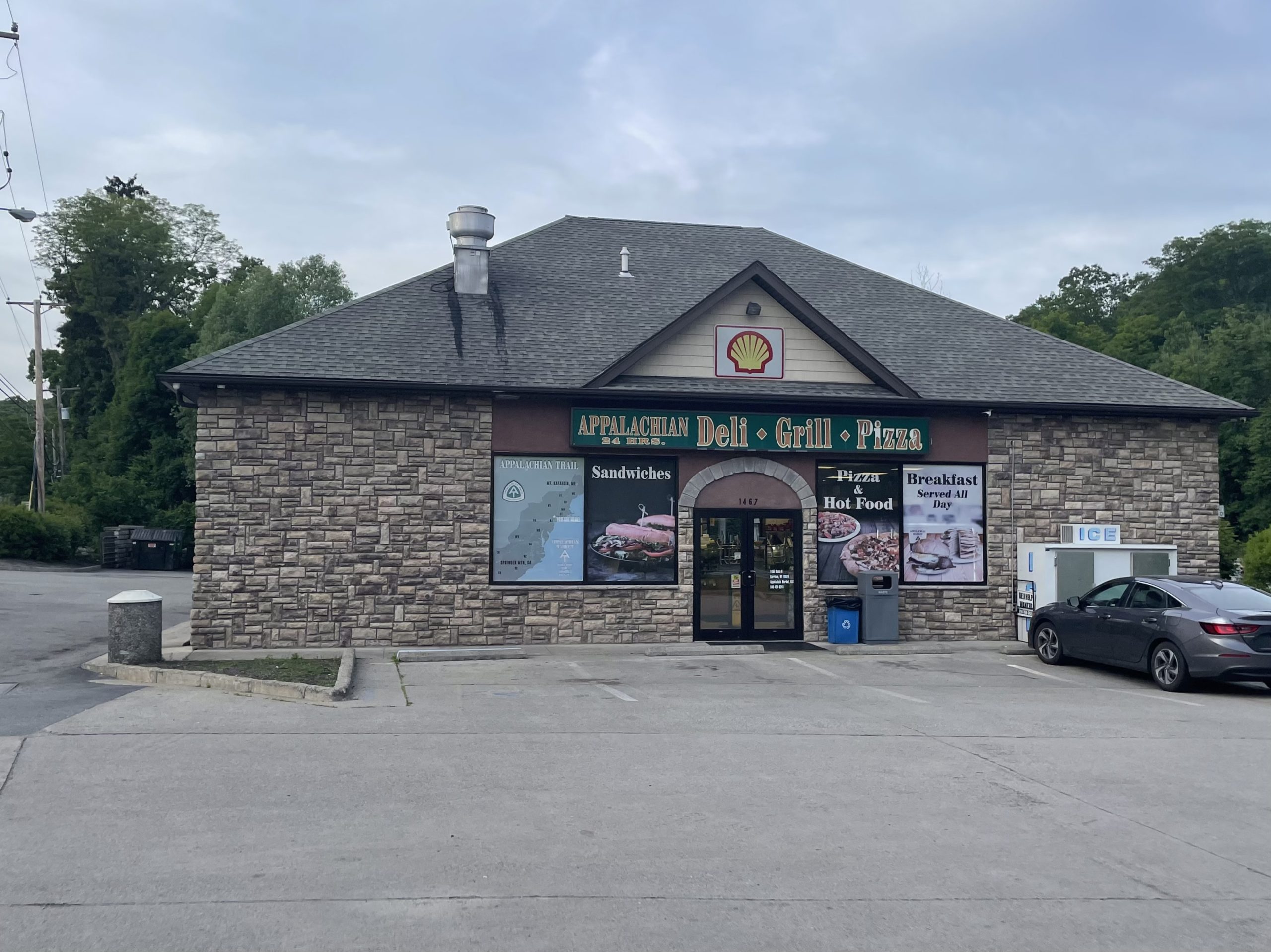
The Appalachian Deli, one of many trailside establishments in New York. They’ve got a mean roasted veggie sandwich.
That day the trail ran north along a rocky ridge with few views. I scrambled up and down through a brushy, boggy wilderness for many hours. In the early afternoon I found more trail magic — two Dutch hikers in the mini-bubble were being treated to burgers by their parents, along with anyone else who stopped by! I had myself a bun with toppings and no burger, but the delicious stewed onions and mustard greens more than made up for the missing patty. Thank you, Dutch hikers’ parents!!
Later in the day I arrived at Canopus Lake, and treated myself to a swim at the deserted beach. As thunderclouds rolled in and the daylight faded, I sprinted up the last hill and arrived, hungry and exhausted, at Corrado’s Pizza. It was 8:40 pm, just twenty minutes before they closed.

The pizza I walked 24 miles for. It was worth it.
I ordered a veggie pizza with broccoli rabe, setting up my tent in the field out back while it baked. Since the rain was picking up outside, the owner kindly let me sit inside past closing. We had a great conversation — he’s had many past careers, including as a researcher and a professional soccer player, and is just generally an interesting guy. I tried some of his homemade gelato, which tastes as good as the best you can find in Italy. It was after ten when I thanked him for his hospitality and went to bed.
4. Nuclear Lake
The rain stopped by morning. I ordered coffee and an egg sandwich from the deli next to Corrado’s and went along my way. The terrain continued as it had been — rocky, woodsy, rolling up and down. I crossed another interstate, I-84. Eventually I stopped at Nuclear Lake, which is just about as odd as the name implies. It was dammed up to use for plutonium research, as part of a facility that was closed and cleaned up 50 years ago.

Isn’t this some of the most inviting water you’ve ever seen? Too bad about the plutonium.
Nuclear Lake is stunningly beautiful, and possibly — just possibly — radioactive. I ran into a guy with a Geiger counter poking around, who said he couldn’t find much evidence of radiation. But (he said) there may be toxic waste stored in barrels at the bottom. Swim at your own risk, I guess.
I met another new thru-hiker there at the lake, as I sat eating leftover pizza under the gaze of hungry geese. This guy had started just four days after me, and somehow I hadn’t run into him till now. His name was Mixed Up, cause that was his job at a feed plant in rural PA. He was a quiet, straightforward person, with a long and easy stride. After the shelter that night, I never saw him again.
A few miles ahead I’d have an even stranger encounter, with a young woman named Froggy who I’d passed way back in March. She and her hiking partner had skipped ahead all the way from central Virginia to the Hudson to beat the heat. We didn’t talk for long, but you can imagine my surprise at seeing her again!

Crossing the Swamp River in Pawling, New York.
At that point I was out of the hills and in the valley of the aptly named Swamp River. This is the first of the northeastern marble valleys, and marks the end of the Hudson Highlands on the trail. This is where the Metro North line goes in towards the city (Appalachian Trail Station open only on weekends), and where the trail begins its final climb into Connecticut. So, after picking up my box from the garden store, I started up through pastures towards the state line.

These pastures get you really up close and personal with the cows.
5. A Wilderness of Caterpillars
I didn’t quite make it to Connecticut that evening, stopping at a shelter area two miles away. There, in addition to Mixed Up and a dour New England lady, I met a former thru-hiker who was doing a southbound section. When he heard we were going north, he laughed and said, “Get ready. You’re about to enter a wilderness of caterpillars.”

This is the Very Hungry Caterpillar, and he’s coming for your trees!
It took a few miles to notice, but he was right. Bristly caterpillars began to appear, chewing on leaves, hanging from threads, and crawling over the ground. A litter of shredded oak leaves covered the trail, and the trees were peculiarly bare for this time of year. And a strange little pitter-patter like a gentle shower marked the fall of the creatures’ droppings down to the forest floor.

No leaves on the hills in June? They’ve all been eaten up!
What I was seeing was an outbreak of Lymantria dispar, the pest formerly known as the ‘gypsy moth’. I’ve learned a lot about its history in recent days, as I struggle to keep caterpillar droppings out of my tea. It was introduced to Boston by a crazed capitalist trying to grow silk, who was looking to find some moth that would suit his purpose. A Lymantria moth escaped from his backyard, and the rest is history. Cycles of arboreal devastation have been recurring every few years since the nineteenth century, defoliating the oak trees of New England. DDT was once used to curb its spread, until its use was banned in the 1970s. Now the best hope for control is a biological agent, a fungus that attacks the voracious bugs. But the fungus needs moist weather in order to thrive, and guess what Connecticut had a few years back? A dry spring. So now the oak trees are bare in early June, while caterpillars swarm like a plague of locusts. It’s simply bizarre.
6. The Mighty Housatonic
Aside from the caterpillars, the Connecticut trail was a lovely 51 miles. The path winds up and down the banks of the Housatonic River, traversing the southern foothills of the Taconic mountains. The landscape is very much like the Hudson Highlands, but less chaotic. You can see where you’re headed in a way that you can’t in the jumbled hills of New York.
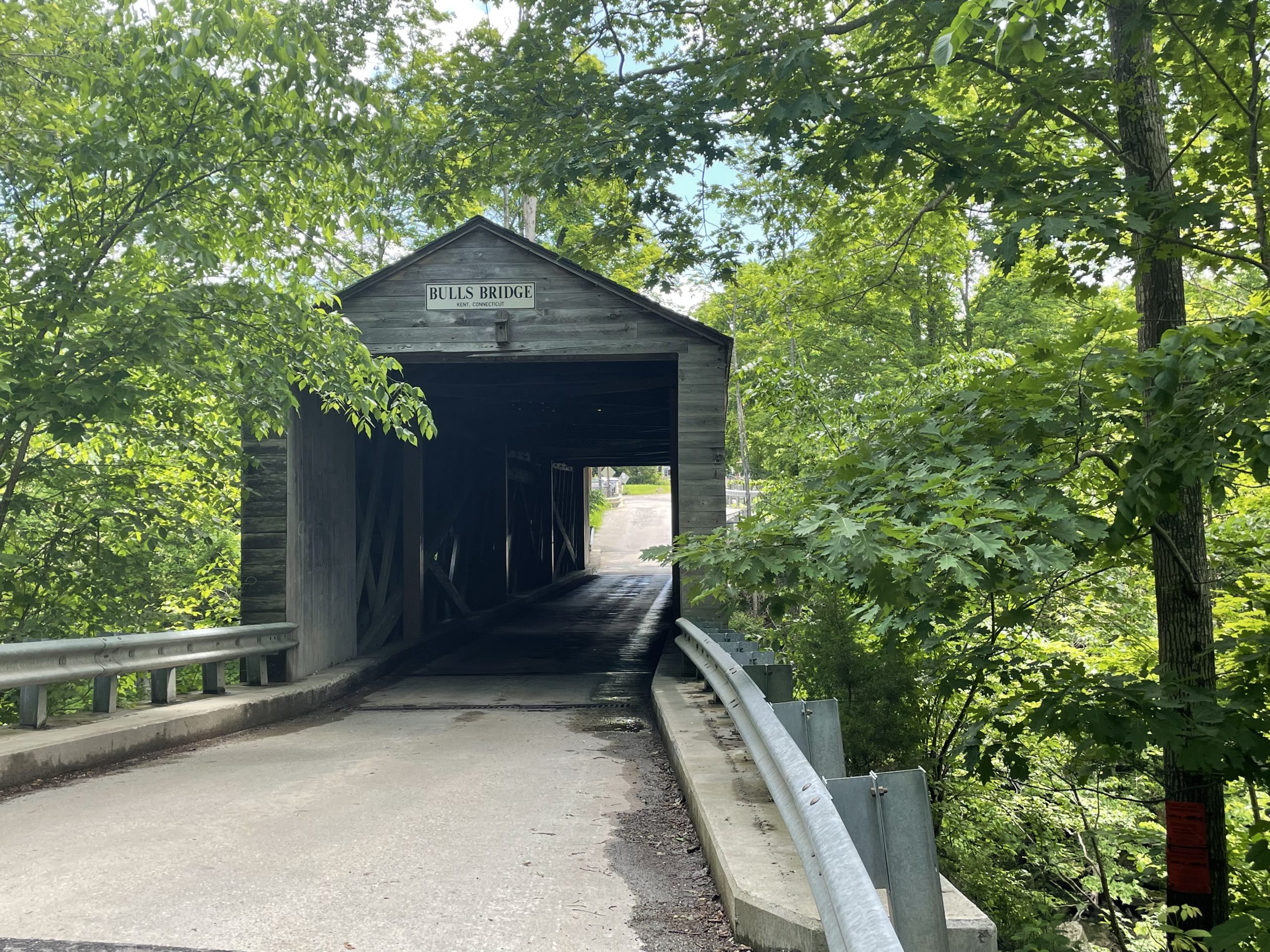
I think this might be the only covered bridge along the trail!
The first New England landmark is called Bulls Bridge. This is roughly the two-thirds point of the trail, an old covered bridge over rapids on the Housatonic River. On the other side is a restaurant, and the Bulls Bridge Country Store. When I got there on Thursday my gear was soaked from a sudden, violent storm, so I stayed a while and dried my tent outside. It’s run by a lovely older lady from India, who made my day by selling chaat snack mix in her country store. I drank coffee and crunched on chickpea-flour puffs in the steamy sunlight until nearly noon.

1700 calories of pure deliciousness.
The trail leaves the river soon after and climbs up Schaghticoke Mountain, home of the Schaghticoke Reservation. Thanks to some research I’d done before I left, I learned it belongs to a small Indigenous nation that’s had some legal difficulties in recent years. Unfortunately, in the course of their legal battles they’ve threatened to close the Appalachian Trail, so I was not surprised to find a brand-new reroute where the Trail used to pass through Schaghticoke land.

Schaghticoke Mountain’s a beautiful and rugged pile of rock.
I soon continued on to a different mountain. The way down from there is known as St. John’s Ledges, and I’d heard it was a challenging descent. So when I got to an overlook and saw a sheer rock face in front of me, I braced myself and started looking for a way down. It was only after a few minutes that I noticed that the trail went off to the left — not down the rock face at all, but through a relatively steep pile of boulders.

Not the trail.
This is something I’ve noticed about the Trail. Certain places reputed to be difficult just aren’t, and others have an undeserved ‘easy’ reputation. Maybe it’s unavoidable that we stretch our impressions towards extremes, but I’ve found myself trusting the hiker lore less and less. I mean, “Virginia is flat” is so untrue that it’s basically a meme!

Walking along the riverbank.
I finished the day on a beautiful flat path along the river, as the shadows deepened and the birds settled in for the night. The moon was out, and if it weren’t for the hungry caterpillars chewing above it would have felt serene. I camped for the night in a shelter area near the riverbank, and was woken the next day by an oriole’s song.
7. Taconic Peaks
Much of the rest of Connecticut was much the same: rocky hills and dips towards the river, skirting decorative villages and fancy estates. On Friday morning I had breakfast at a boutique farm-to-table restaurant, where I ordered the “aegean skillet” and their specialty latte. I met a few more hikers along the way, and we all bonded over the plague of caterpillars. The highest highlight was the Great Falls of the Housatonic, where the river thunders down a rock ledge below an old dam.

Posing in front of the falls!
Then came the ascent out of Salisbury towards the real mountains — the southernmost peaks of the Taconic Range.
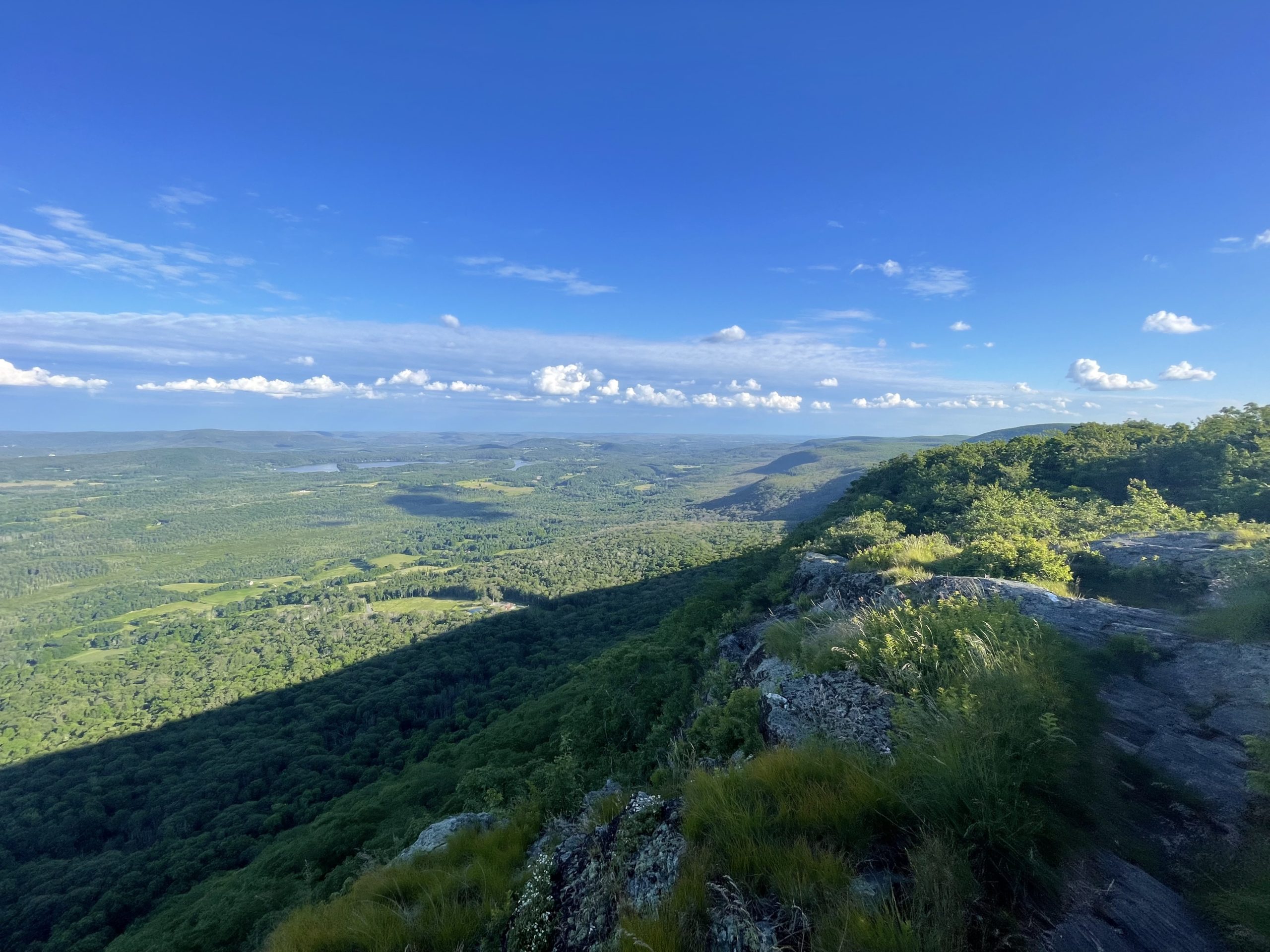
It started with a steep climb up to Lion’s Head knob, on rippled garnet-studded beds of schist. Then the trail kept climbing up and up, surpassing 2000 feet for the first time in weeks. The vegetation changed, and I saw northern plants I hadn’t noticed before. On top of Bear Mountain, stunted birch and pine dotted the peak, and the trail looked down across the Berkshires from bare rock.

The view from Lion’s Head, on the way up Bear Mountain CT.
And then I came down the mountain into Massachusetts. A deep valley, called Sage’s Ravine, cut between this mountain and the next. Among the hemlocks, a stream plummeted through basins and flumes carved into the rock. Where a rivulet tumbled down into the brook, it formed a spout.
Walking the skyline on Mount Race.
The next peak was called Mt. Race, and was higher yet. Towards the summit, the trail hugged a sheer cliff face, so that you seemed to be walking in the sky above the hills. The way both up and down was very tricky, with lots of climbing on steep-angled slabs of rock.
And then came the third and final mountain of the day, Mt. Everett itself. At over 2600 feet, this was the highest I’d been since Virginia. The twisted pitch pine and aspen didn’t leave much room for views, but it was enough to have met the challenge of climbing to the top. For the first time in 1000 miles, I saw a red squirrel.
And with those three peaks, I was done for the day. I arrived in a camping area under tall hemlocks, full of people on this clear, cool Saturday night. I got to bed later than I would have liked, but knowing I’d only have 8 miles to go in the morning. And so it is that now I’m in Great Barrington, a ritzy cutesy town in Western Mass, resting up and changing out gear for the final 600 miles of trail.
Katahdin, here I come! Bring on the moose.

Headed north over the Housatonic in Falls Village, Connecticut.

This website contains affiliate links, which means The Trek may receive a percentage of any product or service you purchase using the links in the articles or advertisements. The buyer pays the same price as they would otherwise, and your purchase helps to support The Trek's ongoing goal to serve you quality backpacking advice and information. Thanks for your support!
To learn more, please visit the About This Site page.

Comments 1
Hey there. Just wondering the details on your gear update for the last push. Maybe I need to be patient for the next post!