 ">
">
Maine – To Monson and The 100 Mile Wilderness
Day 86 – US Route 2/ Gorham to Gentian Pond Shelter
Today was our last full day in New Hampshire. Leaving Gorham, the trail crossed the very full Androscoggin River. Normally I think of water as something pleasant and inviting. But the sound and sight of so much water bursting over the spillway, then colliding, churning, and twisting through rocks and rapids portrayed water at its scariest. We were glad to have a real bridge to walk on.


Shortly after, we climbed Mount Hayes, which provided views southwest to Mount Washington and Mount Madison, as well as south to the Carter-Moriah Range. The sun was even shining as we ate our leftover pizza from last night’s dinner.

For the next nine miles the trail bounced up and down within a 1,000-foot elevation range. Muddy and jungle-like, it was in such poor, ramshackle shape that if it were a building it would have been condemned. It was a relief to arrive at beautiful Gentian Pond and Shelter, until we discovered the site was occupied by a group of about 20 boys on an organized expedition. They occupied all the tent platforms. Then within a few minutes, a matching girls’ group marched in. We had already claimed the shelter, and by 7:00 it was packed with thru-hikers, including several who would have preferred to tent but could not.


We went for a swim in the shallow, warm pond that had a beaver lodge at one end and a waterfall at the other. I saw a leech in the shallowest part. Luckily it was after I finished my swim. Then we ate dinner in the crowded shelter.
In about five miles we would cross into Maine, the last state, tomorrow. It was not without trepidation, given what we’ve heard from several southbound hikers about the water crossings. Nonetheless, we were happy to say goodbye to New Hampshire.
Day 87 – Gentian Pond Shelter to Full Goose Shelter
“Maine is the most beautiful state.” “Maine is just as hard as New Hampshire.” “Maine is harder than New Hampshire.” “Maine is hard for the first 100 miles then gets a lot easier.” “Maine is especially hard now given all the high water crossings.” Everyone seems to have something to say about Maine, particularly relative to New Hampshire. Southbounders are glad to be done with it and northbounders are excited to be in it. We were about to find out.
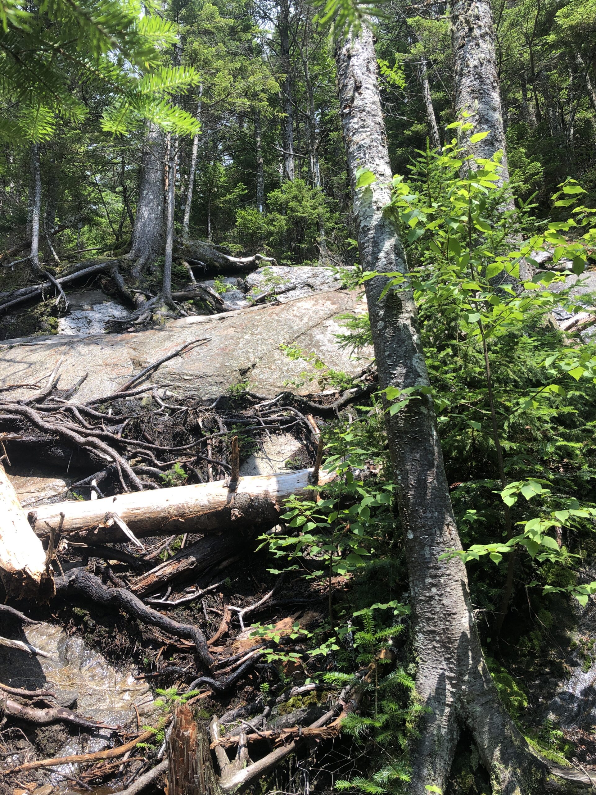
After climbing Mount Success, we left New Hampshire and were welcomed into Maine with a tricky drop through a crack between large two boulders. All our limbs were on high alert as we dangled and aimed. The hike continued in this vein over four more grueling peaks: Mt Carlo, West Goose, East Goose, and North Goose. Each required bouldering and technical skills not encountered on a typical climb or descent. On the ridges and in the valleys, we waded through and around deep muddy bogs. Fortunately, we did not fall in. Welcome to Maine.

Upon reflection, today’s hike turned out to be the slowest and most painstaking ten miles we have covered thus far. It bordered on torture. To add to the difficulty, we got caught in a thunderstorm on top of the last exposed peak. Fortunately, the weather cleared up about an hour later as we settled into Full Goose Shelter. We shared it with Bad Bats, Forest, Daddy Llama, Spice, and Irish.
We knew tomorrow would be a really difficult day, with the Mahoosuc Notch, a giant boulder field, and the Mahoosuc Arm, a steep climb. But we didn’t realize just how hard today would be, and as a result were pretty beat.
Day 88 – Full Goose Shelter to Baldpate Shelter
Before we could make our way through the Mahoosuc Notch, we had to descend a long path to its depths. These steep drops are hard on the knees. Once at the bottom, we hoisted ourselves up and over, and sometimes under, many large boulders that extended for a tortured and twisted mile. It was certainly a memorable, and in many ways fun, section. It was also stressful and a real knee-breaker.


There was no trail as such, but the general direction was marked with white blazes. Eventually the blazes ran out and we found ourselves in front of a deep stream. Paths looked to go off to both the left and the right, but upon following each we came to a dead end. We couldn’t find the trail anywhere and decided to backtrack, looking for blazes that we might have missed. After a while Spice came along and arrived at the same conclusion. Then Kevin realized the obvious. The trail went in the stream. We had wasted about 45 minutes feeling lost before trudging into the knee-deep cold water. We couldn’t see the trail beyond the pool, but after about 25 yards we emerged from the water and reconnected with the land version of the trail. Soon we were out of the Notch and on our way up the Mahoosuc Arm.


This climb then continued on up to Old Speck Mountain, a 4K peak with magnificent views. The uphill portion was quite steep and technical.
Then suddenly the terrain changed and it felt like we were in a different place altogether. We found ourselves actually walking, with minimal knee-breaking drops, rock picking, and swinging from tree trunks. The slope was moderate and we could move at a pace that exceeded one mile per hour. We were finally getting out of the White Mountains.
Day 89 – Baldpate Shelter to Pine Ellis Lodge
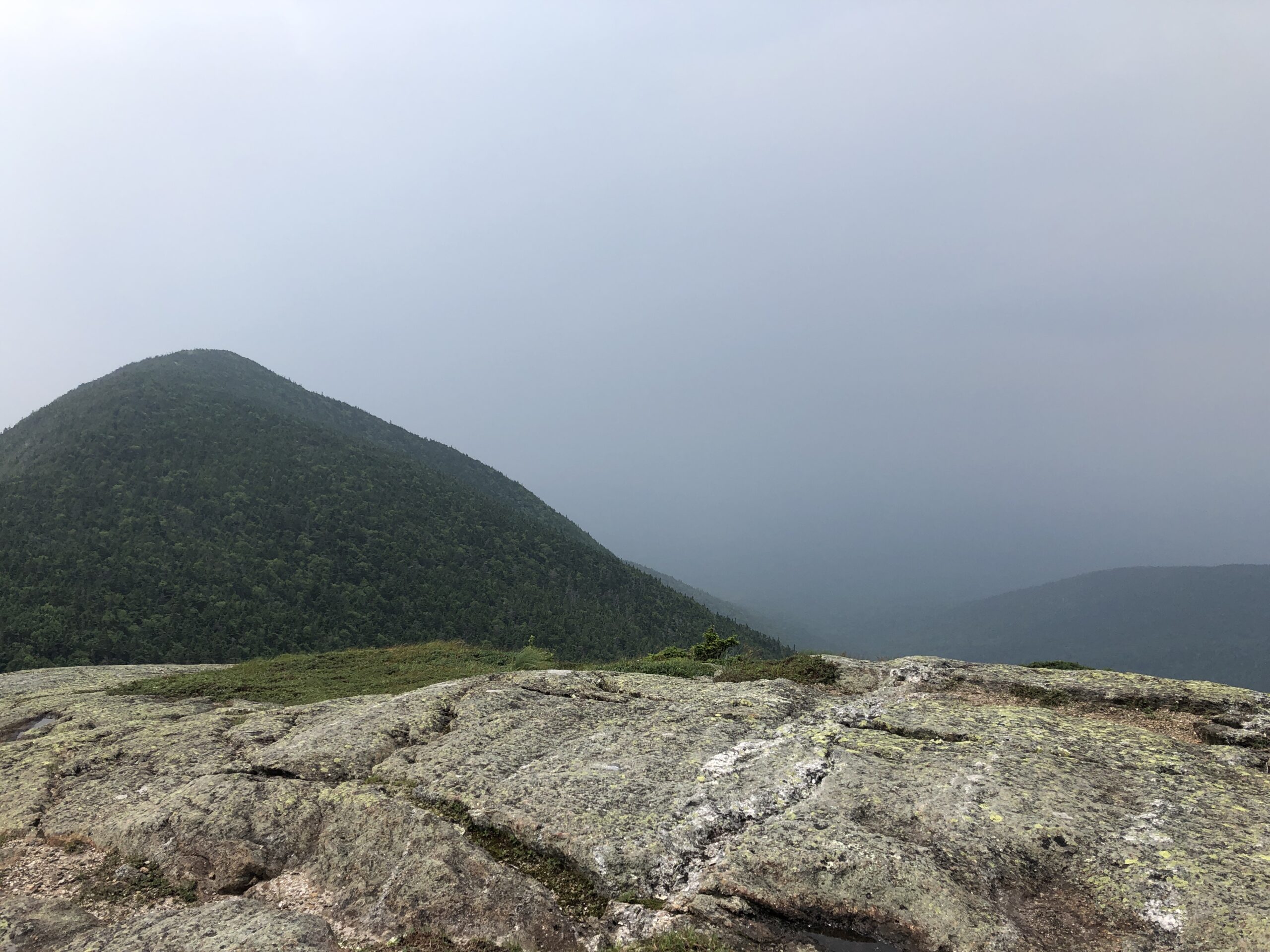
The trail climbed a stone staircase to Baldpate West Peak followed by Baldpate East Peak. The weather was picture-perfect and the trail conditions were ideal. With the exception of a few interrupting spruce trees, we had an expansive 360-degree view from a wide-open slab rock surface. It was the highlight of the week.


We then made our way down to the road where our hostel host picked us up. Before meeting the road, we walked across the Ellis River. Our driver said that a few weeks ago this river was so high that it would have hit Kevin at chest height.
Day 90 – Pine Ellis Lodge to Human Nature Hostel
The “lodge” turned out to be more of a flop house, which was disappointing but not surprising. There are all too many substandard options for lodging on this trail, especially in rural areas.


Today’s forecast called for rain after 2:00. Instead, it rained from mid-morning till about 2:00. The sky was dense with clouds and there was nothing to see.
We intended to tent at a site near a brook, but Kevin felt weak and listless all day, and it was supposed to rain over night. I had read and heard good things about the Human Nature hostel, a timber-frame geodesic dome with an all-inclusive experience that included meals and yoga. Since our tent site was near the road that led to this hostel, I suggested that we stay there instead. Fortunately, I got enough cell service on Mt Moody to make arrangements for both a shuttle and the hostel.


Right before meeting the road, though, we had to cross a knee-deep stream. Our legs and feet were cold and wet, but we had a ride to an excellent hostel that would soon be serving dinner. It turned out to be a good decision, even if we arrived too late for the yoga. Eating a big dinner and breakfast restored Kevin’s calorie deficit.

Day 91 – Human Nature Hostel to Bemis Mountain Road Tent Site
Today was a long and hard one. I fell on my right side into a bog early in the day, then later my left foot post-holed into a thick mud pit. I was submerged up to my knee, and it took a few tries to regain my footing. The dense mud almost kept my shoe. Add two more falls, one on each knee, and multiple slips and slides to complete the picture.


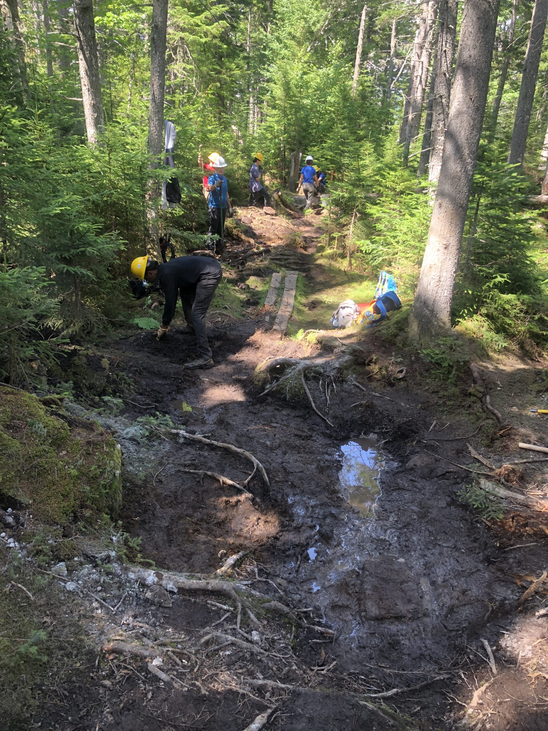
Rocks, mud, roots, bogs. Roots, rocks, bogs, mud. The combination repeats itself endlessly. Less than 30% of what we walk on could legitimately be called a trail. Sure, there are lovely and truly spectacular spots like Baldpate Mountain. And there are funny and relaxing times in the shelters and hostels.
But the misery factor has definitely begun to exceed the pleasure factor. I am ready for this to wrap up, but there are still 234 miles to go. I feel like I’m a few credits short toward completing a degree in something I no longer have any interest in. It is a dilemma. But I’m reminded not to quit on a bad day.
Day 92 – Bemis Mountain Road Tent Site to Rangeley Saddleback Inn
Under sunny skies we hiked along several beautiful ponds and peaks. Fortunately, the only water I submerged myself in was an intentional swim at Sabbath Day Pond.

Upon reaching Rt 4 we ran into Lolly and Pop, who were hiking the AT in sections. They were using their camper and truck as they drove north to hike south in a series of leapfrog segments. They were kind enough to give us a ride into Rangeley. I rode in the back of their truck, an entirely new experience for me. It was a nice way to travel, especially on a beautiful summer day.


Rangeley was a great little town on the lake, surrounded by scenic mountains. It lay to the west of Saddleback Mountain, our next climb.

Day 93 – Rangeley Saddleback Inn to Poplar Ridge Shelter
After buying breakfast and groceries at the IGA, we got a shuttle back to the trail head. It was a late start since the store didn’t open till 8:00.
A hot, dry, sunny day in Maine is hard to imagine. But that’s exactly what we had for our climb up to Saddleback Mountain, The Horn, and Saddleback Junior. All three peaks were above the tree line in an expansive alpine zone with dramatic views in all directions.


We arrived at the shelter and had it to ourselves. Later a NOBO joined us. He started 1,000 miles south of Harpers Ferry at Springer Mountain in Georgia just one month before us. That put things in perspective.
Day 94 – Poplar Ridge Shelter to Crocker Campsite
It hadn’t rained in three days and the trail conditions were greatly improved. Streams that would have been knee high could now be crossed by rock-hopping. Deep liquid mud pits had solidified into a surface that could almost support a person. Waterfalls no longer flowed down the middle of steep, rocky paths.

Despite this, we did have one stream to ford this morning. After that it was time to climb Lone Mountain, the base of Mt Abraham, Spaulding Mountain, and the base of Sugarloaf Mountain. We did not go out of our way to add the two summits since we already had enough to do.
Along the way we passed a plaque commemorating the men of the CCC who helped complete the AT in Maine in 1937. We noted that its entire length was 2,054 miles, as compared to almost 2,200 miles today. It has grown almost 150 miles in that time, not an insignificant amount. I wonder if its length will continue to increase unchecked just like the federal register or the tax code, among other things we have no control over.

Then we descended the steep and rocky slope down to the Carrabassett River. A wood plank that spanned its middle section was tethered to a rock by a cable. When the river floods, as it did very recently, the plank is washed off its base. Fortunately, when we arrived, the plank was set back in place. Otherwise, the day would have also ended with a big stream fording.


Day 95 – Crocker Campsite to Hostel of Maine
By 6:45 we were on our way up two 4K peaks, South and North Crocker Mountains. This was followed by a long descent to Maine Rt 27 where we were picked up by our hostel host. We arrived at the Hostel of Maine before noon and had seemingly lots of time to rest, do laundry, shop for food, and plan the final northern leg of this journey. Before we knew it, however, the day was drawing to a close.


The bad news was that tomorrow’s forecast looked ugly for our last 4K climb, the Bigelow Range. The good news was that the end was in sight. It brought me great pleasure to map out the next two weeks, to reserve our last few lodging spots, and to purchase an August 12 flight home from Portland to Pittsburgh. I planned to keep this in mind when we trudge through tomorrow’s rain.
Day 96 – Hostel of Maine to Little Bigelow Lean-To
The best thing about today was moving 15 miles closer to our goal. It involved climbing the Bigelow Range, which included Bigelow Avery Peak. This was the penultimate 4K mountain on the AT. The last big climb is the terminus, Katahdin.
Seven thru-hikers had planned to head north across the Bigelows today. Last night two of them decided to take a zero day due to the forecast. Just prior to getting the 7:30 a.m. shuttle back to the trail head, the other three dropped out. It was just the two of us heading out into the gloomy day. At first it was just a light drizzle, but it built up to heavier rain that lasted till about 4:30. At least it wasn’t hot.

We raced across the exposed, cloudy alpine tops of the Bigelow Mountains as rain and hail pelted us. Then we continued on through the standard terrain of rocks, roots, water, and mud.
A wet and muddy trail is always more dangerous, harder, and slower than a dry one. That is why today’s 15 mile hike took almost 11 hours to complete. When we arrived at the shelter at 7:00, it was full. Fortunately, we got a tent platform nearby.
Day 97 – Little Bigelow Lean-To to Pierce Pond Lean-To
Our long, hot day contained no big climbs, but was a nearly continuous onslaught of ankle-twisting conditions. So far the trail in Maine is some of the worst yet.

Happily, today’s section was punctuated by three pond stops. The first was early in the day at West Carry Pond, which provided a sunny spot to air our many damp things while we ate lunch. The second, East Carry Pond, was at around 2:00, when a quick swim just couldn’t be passed up. The third was at the end of the day next to our shelter. Pierce Pond was a large, clear, and very picturesque body of water. I was happy to put on my swimsuit and go for a swim at the end of this long, hard day. If only I had a cap and goggles!
Day 98 – Pierce Pond Lean-To to Sterling Inn
We walked four miles along Pierce Pond Stream, with its many waterfalls, to the Kennebec River. The day was hot and sunny, even more so at the open riverbank. Here we boarded the famous and hard-to-imagine-that-it-even-exists canoe ferry that delivered us to the other side near the town of Caratunk.


By 10:00 we were at the Sterling Inn where we took the rest of the day off. We had a surprise reunion with Forest, who was stopping by only to eat and do laundry. Maybe we’ll see him again.

Day 99 – Sterling Inn to Bald Mountain Brook Lean-To
Last night’s rain cooled things off considerably, creating a beautiful, clear, low-humidity day. There were even several sections of decent, walkable trail that took us up to Pleasant Pond Mountain and Middle Mountain. We had incredible views looking back towards the Saddleback Mountains, which really looked like a saddle, and north to unknown, possible future peaks.


Day 100 – Bald Mountain Brook Lean-To to Lake Hebron
We woke up late and found ourselves alone at the campsite. Everyone got a very early start to experience sunrise on Bald Mountain and to get to Monson in time for the last shuttle to Shaw’s Hostel. Our plans were far less ambitious. We beaded up to Bald Mountain at 8:00 and by 9:15 were walking around its top, looking every which way. The combination of mountains and lakes was dramatic, especially the very long and sinuous Moxie Pond. Maybe it would have been more dramatic during sunrise, but we were glad to have slept in.

Later we had a choice to either ford the Piscataquis River, reportedly up to my waist, or take a road walk detour that added one mile. It was raining and thundering around that time, so we opted for the road walk. Walking on the gravel road was a lot less work than navigating the trail, making it faster and giving my sore left knee a break.

As a result of the detour, we reconnected to the AT at a point past our originally intended destination. So we continued on to Lake Hebron, where we found a good stealth tent site for the night, ending at almost 19 miles. Tomorrow would be a short walk to the road crossing north of Monson, the last stop town before the 100 Mile Wilderness.
Day 101 – Lake Hebron to Shaw’s Hostel
Only two cars passed by before we were picked up by a nice gentleman on his way to Bangor. He dropped us off in the surprisingly beautiful and well-maintained town of Monson, situated at one end of Lake Hebron. He pointed out that the former slate mining, then furniture manufacturing, town was in decline for many years when the Portland-based Libra Foundation stepped in from the blue. They bought up over 30 properties and invested more than $10 million in Monson’s revitalization. It definitely shows.


After arriving at Shaw’s Hiker Hostel, we worked hard to sort through our almost seven-day food supply that we received from home. This should get us through the 100 Mile Wilderness and to the Abol Bridge campground just before Mt Katahdin.


We planned to carry the first three days’ supply. The remaining food was packed into two five-gallon buckets, to be delivered by Shaws’s on the fourth day at a designated road crossing. Inevitably, we seemed to always have too much food. It hasn’t gotten any easier to plan accurately. We ended up donating some of it to the large hiker box. I look forward to buying, cooking, and eating “normal” food again.

This website contains affiliate links, which means The Trek may receive a percentage of any product or service you purchase using the links in the articles or advertisements. The buyer pays the same price as they would otherwise, and your purchase helps to support The Trek's ongoing goal to serve you quality backpacking advice and information. Thanks for your support!
To learn more, please visit the About This Site page.

Comments 5
Great post.
I cannot wait for the climb up the Big K.
Congrats
Cheers!
I was thinking about thru hiking the trail. After reading one of your blogs, I don’t want to simply because I don’t want to become jaded or have a shitty attitude
As a fellow thru-hiker, I can attest to the honesty and truthfulness that are exhibited in your postings. The trail is hard and beautiful and stressful and inspiring all at the same time. You certainly don’t deserve comments like the one above for your efforts. Thank you for sharing all of your experiences with us. We’ll be cheering along with you as you and your husband summit.
Hang in there, Mary and Kevin. We’re all rooting for you. You’re doing something really great.